
寄付をします
次の冒険に備えよう:
Amazonアソシエイトとして、このサイトは対象となる購入から手数料を受け取りますが、お客様の負担はありません。
Lixa地形図
地図をクリックすると標高が表示されます。
寄付をします
次の冒険に備えよう:
Amazonアソシエイトとして、このサイトは対象となる購入から手数料を受け取りますが、お客様の負担はありません。
この地図について
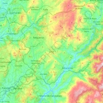
名前:Lixaの地形図、標高、地勢。
場所:Lixa, Felgueiras, Porto, 4615-619, Portugal (41.16122 -8.30551 41.48122 -7.98551)
平均標高:359 m
最低標高:57 m
最大標高:1,075 m
寄付をします
次の冒険に備えよう:
Amazonアソシエイトとして、このサイトは対象となる購入から手数料を受け取りますが、お客様の負担はありません。
その他の地形図
地図をクリックすると、その地形、その標高、その地勢が表示されます。
寄付をします
次の冒険に備えよう:
Amazonアソシエイトとして、このサイトは対象となる購入から手数料を受け取りますが、お客様の負担はありません。
Marco de Canaveses
The city of Marco Canaveses is strongly influenced by its topography, with mainly areas at altitudes between 200 and 600 meters, reaching the highest levels in Aboboreira and Montedeiras Mountains. The highest point of the county is situated at an altitude of 962 meters, in Aboboreira Mountain, which is shared…
平均標高:337 m
Vila Nova de Gaia
Vila Nova de Gaia is located on the southern bank at the mouth of the Douro River, directly across from the municipalities of Porto and Gondomar. In the west, the municipality extends towards the Atlantic Ocean, while in the east it includes the valleys of the Febros and Uíma [pt] rivers, tributaries of the…
平均標高:73 m
寄付をします
次の冒険に備えよう:
Amazonアソシエイトとして、このサイトは対象となる購入から手数料を受け取りますが、お客様の負担はありません。
Matosinhos
At the end of the Bronze Age, much like most of the northwest peninsula, settlements expanded into proto-urban agglomerations at high altitudes (castros), associated with a culture with specific characteristics that predominated until the 1st century. Until today there still exist vestiges of castros dotting…
平均標高:44 m
寄付をします
次の冒険に備えよう:
Amazonアソシエイトとして、このサイトは対象となる購入から手数料を受け取りますが、お客様の負担はありません。
Santo Tirso
The highest point in the municipality is in the Alto de S. Jorge, in the parish of Refojos, with 527 meters of altitude. The municipality's current perimeter is 69 kilometres (43 miles).
平均標高:185 m
寄付をします
次の冒険に備えよう:
Amazonアソシエイトとして、このサイトは対象となる購入から手数料を受け取りますが、お客様の負担はありません。
寄付をします
次の冒険に備えよう:
Amazonアソシエイトとして、このサイトは対象となる購入から手数料を受け取りますが、お客様の負担はありません。
寄付をします
次の冒険に備えよう:
Amazonアソシエイトとして、このサイトは対象となる購入から手数料を受け取りますが、お客様の負担はありません。
寄付をします
次の冒険に備えよう:
Amazonアソシエイトとして、このサイトは対象となる購入から手数料を受け取りますが、お客様の負担はありません。
寄付をします
次の冒険に備えよう:
Amazonアソシエイトとして、このサイトは対象となる購入から手数料を受け取りますが、お客様の負担はありません。
寄付をします
次の冒険に備えよう:
Amazonアソシエイトとして、このサイトは対象となる購入から手数料を受け取りますが、お客様の負担はありません。
Matosinhos
At the end of the Bronze Age, settlements expanded into castros, proto-urban agglomerations at high altitudes. These existed in the northwestern regions of the Iberian Peninsula and predominated until the 1st century. Remnants of castros remain throughout the municipality, the most notable being Castro of…
平均標高:44 m
寄付をします
次の冒険に備えよう:
Amazonアソシエイトとして、このサイトは対象となる購入から手数料を受け取りますが、お客様の負担はありません。
寄付をします
次の冒険に備えよう:
Amazonアソシエイトとして、このサイトは対象となる購入から手数料を受け取りますが、お客様の負担はありません。
寄付をします
次の冒険に備えよう:
Amazonアソシエイトとして、このサイトは対象となる購入から手数料を受け取りますが、お客様の負担はありません。
Vila do Conde
The area of Vila do Conde is part of the granite-metamorphic basement, the Iberian Hercynian massif, that extends from the Spanish border to Espinho (15 km (9 mi) south of Porto). Over the Hercynian bedrock there is a prevalence of sandy beaches, and in other areas, the erosion of these sands has allowed the…
平均標高:29 m
寄付をします
次の冒険に備えよう:
Amazonアソシエイトとして、このサイトは対象となる購入から手数料を受け取りますが、お客様の負担はありません。
寄付をします
次の冒険に備えよう:
Amazonアソシエイトとして、このサイトは対象となる購入から手数料を受け取りますが、お客様の負担はありません。
寄付をします
次の冒険に備えよう:
Amazonアソシエイトとして、このサイトは対象となる購入から手数料を受け取りますが、お客様の負担はありません。