
寄付をします
次の冒険に備えよう:
Amazonアソシエイトとして、このサイトは対象となる購入から手数料を受け取りますが、お客様の負担はありません。
Itajubá地形図
地図をクリックすると標高が表示されます。
寄付をします
次の冒険に備えよう:
Amazonアソシエイトとして、このサイトは対象となる購入から手数料を受け取りますが、お客様の負担はありません。
Itajubá
Itajubá is a municipality in southeastern Minas Gerais state of the Federative Republic of Brazil. It lies in a valley by the Sapucaí river and has terrain elevations ranging from 827 to 1500 metres, occupying an area of 290.45 km2 (112.14 mi2), with a population of 97,334 people (2020 est). Neighboring the city are the mountain slopes of the Serra da Mantiqueira range. The climate sees heavy rain in the summer months with dry weather in the winter.
寄付をします
次の冒険に備えよう:
Amazonアソシエイトとして、このサイトは対象となる購入から手数料を受け取りますが、お客様の負担はありません。
この地図について
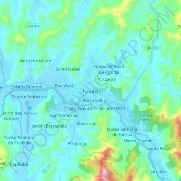
名前:Itajubáの地形図、標高、地勢。
平均標高:923 m
最低標高:837 m
最大標高:1,378 m
寄付をします
次の冒険に備えよう:
Amazonアソシエイトとして、このサイトは対象となる購入から手数料を受け取りますが、お客様の負担はありません。