
寄付をします
次の冒険に備えよう:
Amazonアソシエイトとして、このサイトは対象となる購入から手数料を受け取りますが、お客様の負担はありません。
Baglung地形図
地図をクリックすると標高が表示されます。
寄付をします
次の冒険に備えよう:
Amazonアソシエイトとして、このサイトは対象となる購入から手数料を受け取りますが、お客様の負担はありません。
Baglung
Baglung enjoys warm summers and mild winters. Annual average temperatures range from a maximum of 26.6 °C (79.9 °F) and a minimum of 19.1 °C (66.4 °F). Highs above 35 °C (95 °F) and lows below 0 °C (32 °F) are rare. The average annual rainfall recorded is 1,060.9 mm (41.77 in) in 1982. Rainfall is heavily affected by the monsoon and most of it occurs during the months of June through September. Rest of the year is mostly dry and sunny. Snowfall is extremely rare in the city core, however, higher elevations within the city limits see occasional snow during the winter months. Due to large topographic variation climate ranging from hot subtropical to temperate montane climate can be experienced within the city limits.
寄付をします
次の冒険に備えよう:
Amazonアソシエイトとして、このサイトは対象となる購入から手数料を受け取りますが、お客様の負担はありません。
この地図について
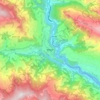
名前:Baglungの地形図、標高、地勢。
場所:Baglung, Gandaki Province, Nepal (28.22511 83.56299 28.30511 83.64299)
平均標高:1,358 m
最低標高:712 m
最大標高:2,288 m
寄付をします
次の冒険に備えよう:
Amazonアソシエイトとして、このサイトは対象となる購入から手数料を受け取りますが、お客様の負担はありません。
その他の地形図
地図をクリックすると、その地形、その標高、その地勢が表示されます。