
寄付をします
次の冒険に備えよう:
Amazonアソシエイトとして、このサイトは対象となる購入から手数料を受け取りますが、お客様の負担はありません。
Potato Lake地形図
地図をクリックすると標高が表示されます。
寄付をします
次の冒険に備えよう:
Amazonアソシエイトとして、このサイトは対象となる購入から手数料を受け取りますが、お客様の負担はありません。
この地図について
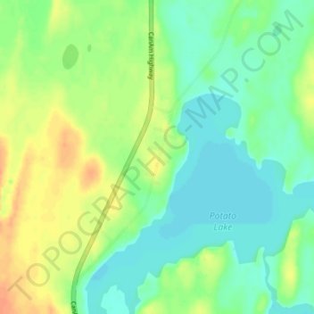
名前:Potato Lakeの地形図、標高、地勢。
平均標高:377 m
最低標高:363 m
最大標高:397 m
寄付をします
次の冒険に備えよう:
Amazonアソシエイトとして、このサイトは対象となる購入から手数料を受け取りますが、お客様の負担はありません。
その他の地形図
地図をクリックすると、その地形、その標高、その地勢が表示されます。
寄付をします
次の冒険に備えよう:
Amazonアソシエイトとして、このサイトは対象となる購入から手数料を受け取りますが、お客様の負担はありません。
Primrose Lake
Canada > Saskatchewan > Unorganized Division No. 18
Primrose Lake has a total surface area of 444 km2 (171 sq mi), 17.7 km2 (6.8 sq mi) of which is in Alberta, and an elevation of 559 metres (1,834 ft). It lies within muskeg and the boreal forest ecozone of Canada. There are several rivers and creeks that flow into the lake with Calder River on the northern…
平均標高:607 m
寄付をします
次の冒険に備えよう:
Amazonアソシエイトとして、このサイトは対象となる購入から手数料を受け取りますが、お客様の負担はありません。
Cree Lake
Canada > Saskatchewan > Unorganized Division No. 18
Cree Lake is the remnant of a much larger proglacial lake. The proglacial lake was formed by the meltwaters of retreating continental glaciers during the last ice age about 8,700 years ago. This proglacial lake flowed south into the Churchill River drainage basin via glacial spillways. After the retreat of the…
平均標高:508 m
寄付をします
次の冒険に備えよう:
Amazonアソシエイトとして、このサイトは対象となる購入から手数料を受け取りますが、お客様の負担はありません。
寄付をします
次の冒険に備えよう:
Amazonアソシエイトとして、このサイトは対象となる購入から手数料を受け取りますが、お客様の負担はありません。