
寄付をします
次の冒険に備えよう:
Amazonアソシエイトとして、このサイトは対象となる購入から手数料を受け取りますが、お客様の負担はありません。
Lagos de Moreno地形図
地図をクリックすると標高が表示されます。
寄付をします
次の冒険に備えよう:
Amazonアソシエイトとして、このサイトは対象となる購入から手数料を受け取りますが、お客様の負担はありません。
Lagos de Moreno
Lagos de Moreno has a subtropical highland climate (Köppen climate classification Cwb) with mild temperatures year round. Temperatures are generally similar for any given month, but daily high and low fluctuations can be very sharp in the winter due in part to the city's altitude and its uneven surroundings. Winters are mild with an average maximum temperature of 23 °C (73.4 °F) in January although nighttime temperatures are often cold, with an average minimum temperature of 3 °C (37.4 °F). Many days are sunny, averaging around 15-19 clear days per month and precipitation is low. Nighttime temperatures regularly fall below 0 °C (32.0 °F) but extended periods of frost are rare.
寄付をします
次の冒険に備えよう:
Amazonアソシエイトとして、このサイトは対象となる購入から手数料を受け取りますが、お客様の負担はありません。
この地図について
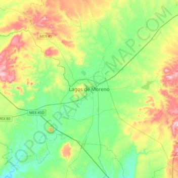
名前:Lagos de Morenoの地形図、標高、地勢。
平均標高:1,956 m
最低標高:1,789 m
最大標高:2,305 m
寄付をします
次の冒険に備えよう:
Amazonアソシエイトとして、このサイトは対象となる購入から手数料を受け取りますが、お客様の負担はありません。