
寄付をします
次の冒険に備えよう:
Amazonアソシエイトとして、このサイトは対象となる購入から手数料を受け取りますが、お客様の負担はありません。
Pandi地形図
地図をクリックすると標高が表示されます。
寄付をします
次の冒険に備えよう:
Amazonアソシエイトとして、このサイトは対象となる購入から手数料を受け取りますが、お客様の負担はありません。
Pandi
Pandi is rich in many natural brooks coming from the mainland itself. In some remote areas the lands are still covered by bamboo trees that naturally thrive and multiplies. Some lands privately owned have mango plantations. In some areas that are privately owned are rock deposits being used for housing materials. The eastern area of Poblacion is gifted by the natural panoramic beauty of the scenery of Sierra Madre Mountains in Luzon. Owing to this the morning climate is always cloudy and cool in some areas of the town proper of Pandi, Bulacan. Some of the natural variations in topography of Pandi land areas have been evened out due to the urbanization of the town. The town's central area has been altered substantially by commercial establishments. Pandi was part of 2nd congressional district from 1987 to 2022. It was moved to 5th district along with Balagtas, Bocaue, and Guiguinto.
寄付をします
次の冒険に備えよう:
Amazonアソシエイトとして、このサイトは対象となる購入から手数料を受け取りますが、お客様の負担はありません。
この地図について
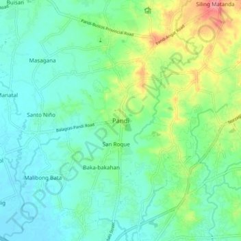
名前:Pandiの地形図、標高、地勢。
場所:Pandi, Bulacan, Central Luzon, 3022, Philippines (14.82541 120.91725 14.90541 120.99725)
平均標高:27 m
最低標高:3 m
最大標高:90 m
寄付をします
次の冒険に備えよう:
Amazonアソシエイトとして、このサイトは対象となる購入から手数料を受け取りますが、お客様の負担はありません。
その他の地形図
地図をクリックすると、その地形、その標高、その地勢が表示されます。
寄付をします
次の冒険に備えよう:
Amazonアソシエイトとして、このサイトは対象となる購入から手数料を受け取りますが、お客様の負担はありません。
寄付をします
次の冒険に備えよう:
Amazonアソシエイトとして、このサイトは対象となる購入から手数料を受け取りますが、お客様の負担はありません。
寄付をします
次の冒険に備えよう:
Amazonアソシエイトとして、このサイトは対象となる購入から手数料を受け取りますが、お客様の負担はありません。