
寄付をします
次の冒険に備えよう:
Amazonアソシエイトとして、このサイトは対象となる購入から手数料を受け取りますが、お客様の負担はありません。
Kandahar地形図
地図をクリックすると標高が表示されます。
寄付をします
次の冒険に備えよう:
Amazonアソシエイトとして、このサイトは対象となる購入から手数料を受け取りますが、お客様の負担はありません。
Kandahar
Kandahar (English: /ˈkændəhɑːr/; Pashto: کندهار Kandahār, Dari: قندهار, Qandahār) is a city in Afghanistan, located in the south of the country on the Arghandab River, at an elevation of 1,010 m (3,310 ft). It is Afghanistan's second largest city after Kabul, with a population of about 614,118. It is the capital of Kandahar Province as well as the de facto capital of the Taliban, formally known as the Islamic Emirate of Afghanistan. It also happens to be the centre of the larger cultural region called Loy Kandahar. In 1709, Mirwais Hotak made the region an independent kingdom and turned Kandahar into the capital of the Hotak dynasty. In 1747, Ahmad Shah Durrani, founder of the Durrani dynasty, made Kandahar the capital of the Afghan Empire. Historically this province is considered as important political area for Afghanistan revelations.
寄付をします
次の冒険に備えよう:
Amazonアソシエイトとして、このサイトは対象となる購入から手数料を受け取りますが、お客様の負担はありません。
この地図について
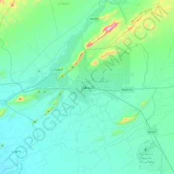
名前:Kandaharの地形図、標高、地勢。
場所:Kandahar, Kandahar Province, 3801, Afghanistan (31.46057 65.55576 31.78057 65.87576)
平均標高:1,048 m
最低標高:940 m
最大標高:1,776 m
寄付をします
次の冒険に備えよう:
Amazonアソシエイトとして、このサイトは対象となる購入から手数料を受け取りますが、お客様の負担はありません。