
寄付をします
次の冒険に備えよう:
Amazonアソシエイトとして、このサイトは対象となる購入から手数料を受け取りますが、お客様の負担はありません。
Bologna地形図
地図をクリックすると標高が表示されます。
寄付をします
次の冒険に備えよう:
Amazonアソシエイトとして、このサイトは対象となる購入から手数料を受け取りますが、お客様の負担はありません。
Bologna
Bologna is situated on the edge of the Po Plain at the foot of the Apennine Mountains, at the meeting of the Reno and Savena river valleys. As Bologna's two main watercourses flow directly to the sea, the town lies outside of the drainage basin of the River Po. The Province of Bologna stretches from the western edge of the Po Plain on the border with Ferrara to the Tuscan-Emilian Apennines. The centre of the town is 54 metres (177 ft) above sea level (while elevation within the municipality ranges from 29 metres (95 ft) in the suburb of Corticella to 300 metres (980 ft) in Sabbiuno and the Colle della Guardia). The Province of Bologna stretches from the Po Plain into the Apennines; the highest point in the province is the peak of Corno alle Scale (in Lizzano in Belvedere) at 1,945 metres (6,381 ft) above sea level.
寄付をします
次の冒険に備えよう:
Amazonアソシエイトとして、このサイトは対象となる購入から手数料を受け取りますが、お客様の負担はありません。
この地図について
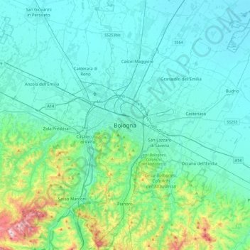
名前:Bolognaの地形図、標高、地勢。
場所:Bologna, Emilia-Romagna, 40121-40141, Italy (44.33382 11.18263 44.65382 11.50263)
平均標高:118 m
最低標高:2 m
最大標高:805 m
寄付をします
次の冒険に備えよう:
Amazonアソシエイトとして、このサイトは対象となる購入から手数料を受け取りますが、お客様の負担はありません。