
寄付をします
次の冒険に備えよう:
Amazonアソシエイトとして、このサイトは対象となる購入から手数料を受け取りますが、お客様の負担はありません。
Shan地形図
地図をクリックすると標高が表示されます。
寄付をします
次の冒険に備えよう:
Amazonアソシエイトとして、このサイトは対象となる購入から手数料を受け取りますが、お客様の負担はありません。
Shan
Mt. Shani (Ingush: Шанлоам, lit. ''icy mountain''; Georgian: შანი; Russian: Шан) also known as Shan and Shanloam is a mountain in the Caucasus. It has an elevation of 4,451 metres (14,603 ft) and is on the international border between Georgia and Ingushetia, Russia.
寄付をします
次の冒険に備えよう:
Amazonアソシエイトとして、このサイトは対象となる購入から手数料を受け取りますが、お客様の負担はありません。
この地図について
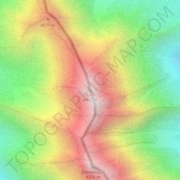
名前:Shanの地形図、標高、地勢。
場所:Shan, Kazbegi Municipality, Mtskheta-Mtianeti, Georgia (42.67598 44.75623 42.67608 44.75633)
平均標高:3,620 m
最低標高:2,882 m
最大標高:4,425 m
寄付をします
次の冒険に備えよう:
Amazonアソシエイトとして、このサイトは対象となる購入から手数料を受け取りますが、お客様の負担はありません。
その他の地形図
地図をクリックすると、その地形、その標高、その地勢が表示されます。
Stepantsminda
Georgia > Mtskheta-Mtianeti > Kazbegi Municipality
The town is located along the banks of the Terek River, 157 kilometers (98 mi) to the north of Tbilisi at an elevation of 1,740 meters (5,710 feet) above sea level. Stepantsminda’s climate is moderately humid with relatively dry, cold winters and long and cool summers. The average annual temperature is 4.9…
平均標高:1,851 m
Gergeti Glacier
Georgia > Mtskheta-Mtianeti > Kazbegi Municipality
Gergeti (Georgian: გერგეთი; also known as Ortsveri) is a glacier located on the southeastern slope of Mt. Kazbek in the Kazbegi District of Georgia. The length of the Gergeti glacier is 7.1 km (4.4 mi) and its surface area is 11 km2 (4.2 sq mi). The tongue of Gergeti descends to 2,900 metres…
平均標高:4,009 m
寄付をします
次の冒険に備えよう:
Amazonアソシエイトとして、このサイトは対象となる購入から手数料を受け取りますが、お客様の負担はありません。
寄付をします
次の冒険に備えよう:
Amazonアソシエイトとして、このサイトは対象となる購入から手数料を受け取りますが、お客様の負担はありません。
Stepantsminda
Georgia > Mtskheta-Mtianeti > Kazbegi Municipality
The town is located along the banks of the Terek River, 157 kilometers (98 mi) to the north of Tbilisi at an elevation of 1,740 meters (5,710 feet) above sea level. Stepantsminda’s climate is moderately humid with relatively dry, cold winters and long and cool summers. The average annual temperature is 4.9…
平均標高:1,851 m