
寄付をします
次の冒険に備えよう:
Amazonアソシエイトとして、このサイトは対象となる購入から手数料を受け取りますが、お客様の負担はありません。
Baabdat地形図
地図をクリックすると標高が表示されます。
寄付をします
次の冒険に備えよう:
Amazonアソシエイトとして、このサイトは対象となる購入から手数料を受け取りますが、お客様の負担はありません。
Baabdat
Baabdat (Arabic: بعبدات) is a town located in the Matn District of Mount Lebanon, 22 km from Beirut at an altitude ranging between 600 and 1100 meters above sea level. The lush pine forests that surround the town make it a very popular summer resort for those escaping the busy coastal cities of Lebanon, especially the capital, Beirut. The town's proximity to Brummana, one of Mount Lebanon's most active summer destinations, makes Baabdat a major tourist destination in the summer.
寄付をします
次の冒険に備えよう:
Amazonアソシエイトとして、このサイトは対象となる購入から手数料を受け取りますが、お客様の負担はありません。
この地図について
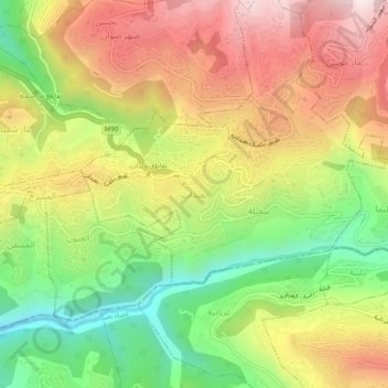
名前:Baabdatの地形図、標高、地勢。
平均標高:740 m
最低標高:340 m
最大標高:1,155 m
寄付をします
次の冒険に備えよう:
Amazonアソシエイトとして、このサイトは対象となる購入から手数料を受け取りますが、お客様の負担はありません。
その他の地形図
地図をクリックすると、その地形、その標高、その地勢が表示されます。
Beit Mery
Lebanon > Mount Lebanon Governorate
1) Beit Mery I is on the right bank of the Beirut River, south southwest of the town at an altitude of approximately 125 metres (410 ft) above sea level. It was found by Jesuit Father Dillenseger who determined it to be an Acheulean site. The material was donated to the Saint Joseph University by the French…
平均標高:460 m
Aley
Lebanon > Mount Lebanon Governorate
The word "Aley" means "high place" in Arabic and in Aramaic, referring to the city's high altitude above sea level (from 600m up to 950m).
平均標高:775 m
寄付をします
次の冒険に備えよう:
Amazonアソシエイトとして、このサイトは対象となる購入から手数料を受け取りますが、お客様の負担はありません。
寄付をします
次の冒険に備えよう:
Amazonアソシエイトとして、このサイトは対象となる購入から手数料を受け取りますが、お客様の負担はありません。
寄付をします
次の冒険に備えよう:
Amazonアソシエイトとして、このサイトは対象となる購入から手数料を受け取りますが、お客様の負担はありません。
寄付をします
次の冒険に備えよう:
Amazonアソシエイトとして、このサイトは対象となる購入から手数料を受け取りますが、お客様の負担はありません。
寄付をします
次の冒険に備えよう:
Amazonアソシエイトとして、このサイトは対象となる購入から手数料を受け取りますが、お客様の負担はありません。
寄付をします
次の冒険に備えよう:
Amazonアソシエイトとして、このサイトは対象となる購入から手数料を受け取りますが、お客様の負担はありません。
Dik El Mehdeh
Lebanon > Mount Lebanon Governorate
Dik El Mehdi (Arabic: ديك المحدي) is a village, at 325 meters elevation, in the Matn District governorate of Mount Lebanon. Its population has been estimated at 2,096 by Aayroun. The village is around 18 km. from Beirut. The majority of it inhabitants derives from the Ashkar family. Many of its…
平均標高:246 m
寄付をします
次の冒険に備えよう:
Amazonアソシエイトとして、このサイトは対象となる購入から手数料を受け取りますが、お客様の負担はありません。
寄付をします
次の冒険に備えよう:
Amazonアソシエイトとして、このサイトは対象となる購入から手数料を受け取りますが、お客様の負担はありません。
寄付をします
次の冒険に備えよう:
Amazonアソシエイトとして、このサイトは対象となる購入から手数料を受け取りますが、お客様の負担はありません。
寄付をします
次の冒険に備えよう:
Amazonアソシエイトとして、このサイトは対象となる購入から手数料を受け取りますが、お客様の負担はありません。
Baskinta
Lebanon > Mount Lebanon Governorate
Baskinta (Arabic: بسكنتا) is a Lebanese village situated at an altitude ranging from 1250 metres above sea level and climbs up to approximately 1800 meters of height at Qanat Bakish, making it one of the highest villages of Lebanon. It is located 43 kilometers north east of Beirut.
平均標高:1,396 m
寄付をします
次の冒険に備えよう:
Amazonアソシエイトとして、このサイトは対象となる購入から手数料を受け取りますが、お客様の負担はありません。
寄付をします
次の冒険に備えよう:
Amazonアソシエイトとして、このサイトは対象となる購入から手数料を受け取りますが、お客様の負担はありません。
寄付をします
次の冒険に備えよう:
Amazonアソシエイトとして、このサイトは対象となる購入から手数料を受け取りますが、お客様の負担はありません。
寄付をします
次の冒険に備えよう:
Amazonアソシエイトとして、このサイトは対象となる購入から手数料を受け取りますが、お客様の負担はありません。
寄付をします
次の冒険に備えよう:
Amazonアソシエイトとして、このサイトは対象となる購入から手数料を受け取りますが、お客様の負担はありません。
Baskinta
Lebanon > Mount Lebanon Governorate
Baskinta (Arabic: بسكنتا) is a Lebanese village situated at an altitude ranging from 1250 metres above sea level and climbs up to approximately 1800 meters of height at Qanat Bakish, making it one of the highest villages of Lebanon. It is located 43 kilometers north east of Beirut.
平均標高:1,396 m
寄付をします
次の冒険に備えよう:
Amazonアソシエイトとして、このサイトは対象となる購入から手数料を受け取りますが、お客様の負担はありません。
寄付をします
次の冒険に備えよう:
Amazonアソシエイトとして、このサイトは対象となる購入から手数料を受け取りますが、お客様の負担はありません。
寄付をします
次の冒険に備えよう:
Amazonアソシエイトとして、このサイトは対象となる購入から手数料を受け取りますが、お客様の負担はありません。
Ain Saadeh
Lebanon > Mount Lebanon Governorate
The average annual rainfall is 825 millimetres (32.5 in), with the large majority of it falling from October to April. Much of the autumn and spring rain falls in heavy downpours on a limited number of days, but in winter it is spread more evenly over many days. Summer receives very little rainfall, if any.…
平均標高:335 m
寄付をします
次の冒険に備えよう:
Amazonアソシエイトとして、このサイトは対象となる購入から手数料を受け取りますが、お客様の負担はありません。
Antelias
Lebanon > Mount Lebanon Governorate
The municipality of Antelias - Naqqach is located in the Kaza of Matn in Mount Lebanon, one of the eight mohafazats (governorates) of Lebanon. Antelias - Naqqach is 8 kilometers (4.9712 mi) from Beyrouth (Beirut), the capital of Lebanon. Its elevation is 10 meters (32.81 ft; 10.936 yd) above sea level.…
平均標高:65 m
寄付をします
次の冒険に備えよう:
Amazonアソシエイトとして、このサイトは対象となる購入から手数料を受け取りますが、お客様の負担はありません。
Aley
Lebanon > Mount Lebanon Governorate
The word "Aley" means "high place" in Arabic and in Aramaic, referring to the city's high altitude above sea level (from 600m up to 950m).
平均標高:775 m
寄付をします
次の冒険に備えよう:
Amazonアソシエイトとして、このサイトは対象となる購入から手数料を受け取りますが、お客様の負担はありません。
寄付をします
次の冒険に備えよう:
Amazonアソシエイトとして、このサイトは対象となる購入から手数料を受け取りますが、お客様の負担はありません。
寄付をします
次の冒険に備えよう:
Amazonアソシエイトとして、このサイトは対象となる購入から手数料を受け取りますが、お客様の負担はありません。
Aley
Lebanon > Mount Lebanon Governorate
The word "Aley" means "high place" in Arabic and in Aramaic, referring to the city's high altitude above sea level (from 600m up to 950m).
平均標高:775 m