
寄付をします
次の冒険に備えよう:
Amazonアソシエイトとして、このサイトは対象となる購入から手数料を受け取りますが、お客様の負担はありません。
Bottle Peak地形図
地図をクリックすると標高が表示されます。
寄付をします
次の冒険に備えよう:
Amazonアソシエイトとして、このサイトは対象となる購入から手数料を受け取りますが、お客様の負担はありません。
この地図について
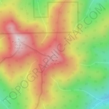
名前:Bottle Peakの地形図、標高、地勢。
場所:Bottle Peak, Grand County, Colorado, United States (39.90216 -105.93645 39.90226 -105.93635)
平均標高:3,283 m
最低標高:2,949 m
最大標高:3,582 m
寄付をします
次の冒険に備えよう:
Amazonアソシエイトとして、このサイトは対象となる購入から手数料を受け取りますが、お客様の負担はありません。
その他の地形図
地図をクリックすると、その地形、その標高、その地勢が表示されます。
Fraser
United States > Colorado > Grand County
Fraser is located in southeastern Grand County at 39°56′39″N 105°48′48″W / 39.94417°N 105.81333°W / 39.94417; -105.81333 (39.944158, -105.813355), at an elevation of 8,574 feet (2,613 m) above sea level. It is bordered to the south by the town of Winter Park and to the north by…
平均標高:2,696 m
Hot Sulphur Springs
United States > Colorado > Grand County
Hot Sulphur Springs is a statutory town and the county seat of Grand County, Colorado, United States. The town is located near Byers Canyon between Granby and Kremmling, 95 miles (153 km) northwest of Denver and 30 miles (48 km) northwest of Winter Park. The town population was 687 at the 2020 census. Its…
平均標高:2,446 m
寄付をします
次の冒険に備えよう:
Amazonアソシエイトとして、このサイトは対象となる購入から手数料を受け取りますが、お客様の負担はありません。