
寄付をします
次の冒険に備えよう:
Amazonアソシエイトとして、このサイトは対象となる購入から手数料を受け取りますが、お客様の負担はありません。
Elmdon Heath地形図
地図をクリックすると標高が表示されます。
寄付をします
次の冒険に備えよう:
Amazonアソシエイトとして、このサイトは対象となる購入から手数料を受け取りますが、お客様の負担はありません。
この地図について
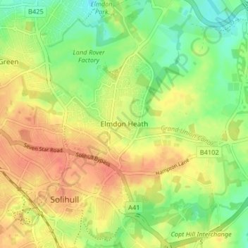
名前:Elmdon Heathの地形図、標高、地勢。
平均標高:120 m
最低標高:97 m
最大標高:139 m
寄付をします
次の冒険に備えよう:
Amazonアソシエイトとして、このサイトは対象となる購入から手数料を受け取りますが、お客様の負担はありません。
その他の地形図
地図をクリックすると、その地形、その標高、その地勢が表示されます。
寄付をします
次の冒険に備えよう:
Amazonアソシエイトとして、このサイトは対象となる購入から手数料を受け取りますが、お客様の負担はありません。
寄付をします
次の冒険に備えよう:
Amazonアソシエイトとして、このサイトは対象となる購入から手数料を受け取りますが、お客様の負担はありません。
Hockley Heath
United Kingdom > England > Metropolitan Borough of Solihull
By the 18th century the manor had passed to the Archers of Umberslade Hall and the hamlet was briefly reoriented around its Umberslade area. The Umberslade estate sits on the border of Nuthurst and Tanworth in Arden and had been built for the Archer family in 1680. Lord Archer raised a 70 feet (21 m) limestone…
平均標高:134 m