
寄付をします
次の冒険に備えよう:
Amazonアソシエイトとして、このサイトは対象となる購入から手数料を受け取りますが、お客様の負担はありません。
La Vigne地形図
地図をクリックすると標高が表示されます。
寄付をします
次の冒険に備えよう:
Amazonアソシエイトとして、このサイトは対象となる購入から手数料を受け取りますが、お客様の負担はありません。
この地図について
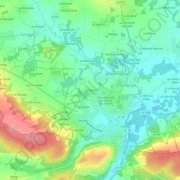
名前:La Vigneの地形図、標高、地勢。
平均標高:33 m
最低標高:0 m
最大標高:94 m
寄付をします
次の冒険に備えよう:
Amazonアソシエイトとして、このサイトは対象となる購入から手数料を受け取りますが、お客様の負担はありません。
その他の地形図
地図をクリックすると、その地形、その標高、その地勢が表示されます。
La Chapelle-Gaceline
France > Bretagne > Morbihan > La Gacilly
La superficie de la commune est de 779 hectares ; son altitude varie de 5 à 52 mètres.
平均標高:25 m
La Gacilly
France > Bretagne > Morbihan > La Gacilly
La superficie de la commune est de 1 648 hectares ; son altitude varie de 4 à 98 mètres.
平均標高:41 m
Glénac
France > Bretagne > Morbihan > La Gacilly
La superficie de l’ancienne commune est de 1 370 hectares (13,7 km2) ; son altitude varie entre 2 et 87 m.
平均標高:31 m
La Gacilly
France > Bretagne > Morbihan > La Gacilly
La superficie de la commune est de 1 648 hectares ; son altitude varie de 4 à 98 mètres.
平均標高:41 m
寄付をします
次の冒険に備えよう:
Amazonアソシエイトとして、このサイトは対象となる購入から手数料を受け取りますが、お客様の負担はありません。