
寄付をします
次の冒険に備えよう:
Amazonアソシエイトとして、このサイトは対象となる購入から手数料を受け取りますが、お客様の負担はありません。
Ciudad Mante地形図
地図をクリックすると標高が表示されます。
寄付をします
次の冒険に備えよう:
Amazonアソシエイトとして、このサイトは対象となる購入から手数料を受け取りますが、お客様の負担はありません。
Ciudad Mante
El Cielo (The Heaven) a protected cloud forest covers a land mass of 144,530 hectares (~357,129 acres) and is a paradise for the great quantity of species that inhabit it. There are 175 distinct species of migratory birds and 225 local fowl, various amphibious and mammals, as well as white tail deer, jaguar and black bear. This is due to the unique climatological, biological and topographical conditions in El Cielo.
寄付をします
次の冒険に備えよう:
Amazonアソシエイトとして、このサイトは対象となる購入から手数料を受け取りますが、お客様の負担はありません。
この地図について
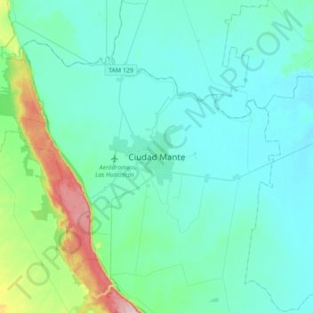
名前:Ciudad Manteの地形図、標高、地勢。
場所:Ciudad Mante, El Mante, Tamaulipas, 89800, Mexico (22.58113 -99.13141 22.90113 -98.81141)
平均標高:105 m
最低標高:47 m
最大標高:468 m
寄付をします
次の冒険に備えよう:
Amazonアソシエイトとして、このサイトは対象となる購入から手数料を受け取りますが、お客様の負担はありません。