
寄付をします
次の冒険に備えよう:
Amazonアソシエイトとして、このサイトは対象となる購入から手数料を受け取りますが、お客様の負担はありません。
Campeche City地形図
地図をクリックすると標高が表示されます。
寄付をします
次の冒険に備えよう:
Amazonアソシエイトとして、このサイトは対象となる購入から手数料を受け取りますが、お客様の負担はありません。
Campeche City
Before the current shield was adopted, there was a process to constitute a shield as an officer. The first project was presented in 1772 before the possible elevation to the title of city of the town of San Francisco de Campeche, when requested by the Cabildo de Campeche in a contest for the election of shield de Armas. The first design was submitted by Juan Antonio Rexo and Peñuelas on September 24 of that year but was rejected on October 17 for not being subject to the rules of heraldry. Ramón Zazo and Ortega subsequently presented three projects; the first two were rejected but finally the third was approved in council on November 7, 1777. The shield was approved by his majesty Carlos III of Spain with the certificate of: "the City Title is granted to the town of San Francisco de Campeche."
寄付をします
次の冒険に備えよう:
Amazonアソシエイトとして、このサイトは対象となる購入から手数料を受け取りますが、お客様の負担はありません。
この地図について
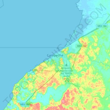
名前:Campeche Cityの地形図、標高、地勢。
平均標高:16 m
最低標高:-3 m
最大標高:108 m
寄付をします
次の冒険に備えよう:
Amazonアソシエイトとして、このサイトは対象となる購入から手数料を受け取りますが、お客様の負担はありません。