
寄付をします
次の冒険に備えよう:
Amazonアソシエイトとして、このサイトは対象となる購入から手数料を受け取りますが、お客様の負担はありません。
San Cristóbal地形図
地図をクリックすると標高が表示されます。
寄付をします
次の冒険に備えよう:
Amazonアソシエイトとして、このサイトは対象となる購入から手数料を受け取りますが、お客様の負担はありません。
San Cristóbal
The city and municipality are located in a region called the Chiapas Highlands or Central Highlands. Two thirds of the municipality is made up of mountainous terrain with the rest valley floor. The city proper is located at 2,200 meters above sea level in a small valley surrounded by hills. The most important of these hills include Cerro Huitepec, San José Bocomtenelté, Cerro San Felipe, Cerro El Extranjero, Cerro Cruz Carreta, El Arcotete and Cerro Tzontehuitz. While it is in a tropical zone, its climate is temperate due to the altitude. The climate is also humid, with cloud cover in the winter months that keeps temperatures down and can produce cold nights. Average temperature between December and April is 18 °C. The area receives most of its rain in the summer to early fall. However, the cloud cover that exists in winter is generally absent and daytime temperatures can go up to 35 °C with high humidity.
寄付をします
次の冒険に備えよう:
Amazonアソシエイトとして、このサイトは対象となる購入から手数料を受け取りますが、お客様の負担はありません。
この地図について
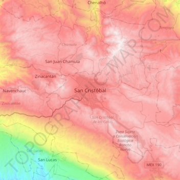
名前:San Cristóbalの地形図、標高、地勢。
平均標高:2,038 m
最低標高:456 m
最大標高:2,881 m
寄付をします
次の冒険に備えよう:
Amazonアソシエイトとして、このサイトは対象となる購入から手数料を受け取りますが、お客様の負担はありません。