
寄付をします
次の冒険に備えよう:
Amazonアソシエイトとして、このサイトは対象となる購入から手数料を受け取りますが、お客様の負担はありません。
Ramos Arizpe地形図
地図をクリックすると標高が表示されます。
寄付をします
次の冒険に備えよう:
Amazonアソシエイトとして、このサイトは対象となる購入から手数料を受け取りますが、お客様の負担はありません。
Ramos Arizpe
Ramos Arizpe has a desert climate (Köppen climate classification BWh Owing to its altitude of 1,400 to 1,500 m (4,600 to 4,900 ft) above sea level, temperatures are milder than other desert cities at lower elevations. Winters are mild with warm temperatures during the day and cold nights. The January average temperature is 11.9 °C (53.4 °F). On average, temperatures drop below freezing on 18 days per year, which can occur in the months November to April. Occasionally, it can receive snowfall. Precipitation is low during the winter months and many days are clear and sunny, averaging 20-22 clear days from December to March.
寄付をします
次の冒険に備えよう:
Amazonアソシエイトとして、このサイトは対象となる購入から手数料を受け取りますが、お客様の負担はありません。
この地図について
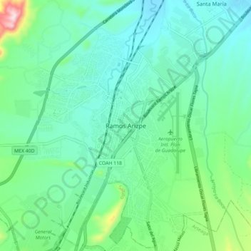
名前:Ramos Arizpeの地形図、標高、地勢。
場所:Ramos Arizpe, Coahuila, 25900, Mexico (25.50079 -100.98667 25.58079 -100.90667)
平均標高:1,426 m
最低標高:1,337 m
最大標高:1,756 m
寄付をします
次の冒険に備えよう:
Amazonアソシエイトとして、このサイトは対象となる購入から手数料を受け取りますが、お客様の負担はありません。