
このサイトをサポートしていただきありがとうございます ❤️
寄付をします
寄付をします
次の冒険に備えよう:
Amazonアソシエイトとして、このサイトは対象となる購入から手数料を受け取りますが、お客様の負担はありません。
Tanjay地形図
地図をクリックすると標高が表示されます。
このサイトをサポートしていただきありがとうございます ❤️
寄付をします
寄付をします
次の冒険に備えよう:
Amazonアソシエイトとして、このサイトは対象となる購入から手数料を受け取りますが、お客様の負担はありません。
この地図について
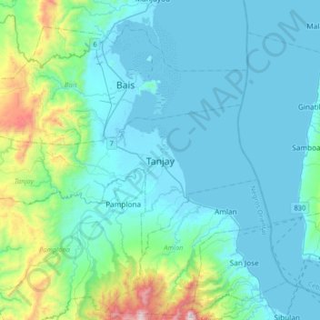
名前:Tanjayの地形図、標高、地勢。
場所:Tanjay, Negros Oriental, Central Visayas, 6204, Philippines (9.35645 122.99664 9.67645 123.31664)
平均標高:172 m
最低標高:-1 m
最大標高:1,233 m
このサイトをサポートしていただきありがとうございます ❤️
寄付をします
寄付をします
次の冒険に備えよう:
Amazonアソシエイトとして、このサイトは対象となる購入から手数料を受け取りますが、お客様の負担はありません。
その他の地形図
地図をクリックすると、その地形、その標高、その地勢が表示されます。
Dumaguete
As a coastal city, it is bounded on the east by the Bohol Sea and the Tañon Strait, serving as a natural border of southeastern Negros Island Region to the neighboring Central Visayas. The city's topography is generally flat from two to six kilometers from the shoreline. It slopes gently upwards to the…
平均標高:55 m
このサイトをサポートしていただきありがとうございます ❤️
寄付をします
寄付をします
次の冒険に備えよう:
Amazonアソシエイトとして、このサイトは対象となる購入から手数料を受け取りますが、お客様の負担はありません。