
寄付をします
次の冒険に備えよう:
Amazonアソシエイトとして、このサイトは対象となる購入から手数料を受け取りますが、お客様の負担はありません。
Mariana Islands地形図
地図をクリックすると標高が表示されます。
寄付をします
次の冒険に備えよう:
Amazonアソシエイトとして、このサイトは対象となる購入から手数料を受け取りますが、お客様の負担はありません。
この地図について
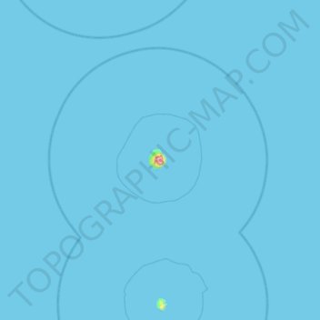
名前:Mariana Islandsの地形図、標高、地勢。
平均標高:1 m
最低標高:0 m
最大標高:680 m
寄付をします
次の冒険に備えよう:
Amazonアソシエイトとして、このサイトは対象となる購入から手数料を受け取りますが、お客様の負担はありません。
その他の地形図
地図をクリックすると、その地形、その標高、その地勢が表示されます。
Anatahan Island
United States > Northern Mariana Islands > Northern Islands Municipality
Anatahan is roughly elliptical in shape, with a length of 9 kilometers (5.6 mi) and a width of 4 km (2.5 mi) and an area of 33.9 km2 (13.1 sq mi). The island is the summit of a stratovolcano which reaches an altitude of 790 m (2,592 ft) above sea level at its highest peak.
平均標高:94 m
Alamagan Island
United States > Northern Mariana Islands > Northern Islands Municipality
Alamagan is roughly elliptical in shape, with a length of 4.8 kilometers (3.0 mi), width of 4 km (2.5 mi), and area of 13 km2 (5.0 sq mi). The entire island is the summit of a stratovolcano which rises over 4,000 meters (13,120 ft) from the ocean floor, to an altitude of 744 m (2,441 ft) above sea level at…
平均標高:148 m
寄付をします
次の冒険に備えよう:
Amazonアソシエイトとして、このサイトは対象となる購入から手数料を受け取りますが、お客様の負担はありません。