
寄付をします
次の冒険に備えよう:
Amazonアソシエイトとして、このサイトは対象となる購入から手数料を受け取りますが、お客様の負担はありません。
Ashburn地形図
地図をクリックすると標高が表示されます。
寄付をします
次の冒険に備えよう:
Amazonアソシエイトとして、このサイトは対象となる購入から手数料を受け取りますが、お客様の負担はありません。
この地図について
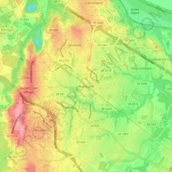
名前:Ashburnの地形図、標高、地勢。
場所:Ashburn, Loudoun County, Virginia, 20147, United States (39.00372 -77.52749 39.08372 -77.44749)
平均標高:87 m
最低標高:32 m
最大標高:144 m
寄付をします
次の冒険に備えよう:
Amazonアソシエイトとして、このサイトは対象となる購入から手数料を受け取りますが、お客様の負担はありません。
その他の地形図
地図をクリックすると、その地形、その標高、その地勢が表示されます。
Leesburg
United States > Virginia > Loudoun County
Leesburg is located northeast of the center of Loudoun County at 39°7′N 77°33′W / 39.117°N 77.550°W / 39.117; -77.550 (39.109, −77.558), It is part of the northern Virginia Piedmont and sits at the base of the easternmost chain of the Blue Ridge Mountains, Catoctin Mountain. The town lies in…
平均標高:113 m
Ashburn
United States > Virginia > Loudoun County > Ashburn
Ashburn is located at 39°02′37″N 077°29′15″W / 39.04361°N 77.48750°W / 39.04361; -77.48750 (39.0437192, −77.4874899) and its average elevation is 295 feet (90 m) above sea level. According to the 2010 United States Census, the CDP has a total area of 17.287 square miles (44.77 km2), of…
平均標高:86 m
寄付をします
次の冒険に備えよう:
Amazonアソシエイトとして、このサイトは対象となる購入から手数料を受け取りますが、お客様の負担はありません。
Middleburg
United States > Virginia > Loudoun County
According to the United States Census Bureau, the town has a total area of 0.6 square mile (1.5 km2), all land. The elevation is 486 feet.
平均標高:143 m
Middleburg
United States > Virginia > Loudoun County
According to the United States Census Bureau, the town has a total area of 0.6 square mile (1.5 km2), all land. The elevation is 486 feet.
平均標高:143 m
寄付をします
次の冒険に備えよう:
Amazonアソシエイトとして、このサイトは対象となる購入から手数料を受け取りますが、お客様の負担はありません。
Middleburg
United States > Virginia > Loudoun County
According to the United States Census Bureau, the town has a total area of 0.6 square mile (1.5 km2), all land. The elevation is 486 feet.
平均標高:143 m
寄付をします
次の冒険に備えよう:
Amazonアソシエイトとして、このサイトは対象となる購入から手数料を受け取りますが、お客様の負担はありません。
寄付をします
次の冒険に備えよう:
Amazonアソシエイトとして、このサイトは対象となる購入から手数料を受け取りますが、お客様の負担はありません。
Ashburn
United States > Virginia > Loudoun County > Ashburn
Ashburn is located in eastern Loudoun County at 39°02′37″N 077°29′15″W / 39.04361°N 77.48750°W / 39.04361; -77.48750 (39.0437192, −77.4874899) and its average elevation is 295 feet (90 m) above sea level. It is 7 miles (11 km) southeast of Leesburg, the county seat, and the same distance…
平均標高:86 m
寄付をします
次の冒険に備えよう:
Amazonアソシエイトとして、このサイトは対象となる購入から手数料を受け取りますが、お客様の負担はありません。
Sterling
United States > Virginia > Loudoun County
According to the USGS, Sterling has an average elevation of 289 feet (88 m) above sea level. The original center of Sterling is located at 39°00'22.4"N 77°25'43.0"W. Sterling is part of the Chesapeake Bay watershed, and Greater Sterling borders the Potomac River.
平均標高:97 m
Sterling
United States > Virginia > Loudoun County > Sterling
According to the USGS, Sterling has an average elevation of 289 feet (88 m) above sea level. The original center of Sterling is located at 39°00'22.4"N 77°25'43.0"W. Sterling is part of the Chesapeake Bay watershed, and Greater Sterling borders the Potomac River.
平均標高:97 m
Leesburg
United States > Virginia > Loudoun County
Leesburg is located northeast of the center of Loudoun County at 39°7′N 77°33′W / 39.117°N 77.550°W / 39.117; -77.550 (39.109, −77.558), It is part of the northern Virginia Piedmont and sits at the base of the easternmost chain of the Blue Ridge Mountains, Catoctin Mountain. The town lies in…
平均標高:113 m
寄付をします
次の冒険に備えよう:
Amazonアソシエイトとして、このサイトは対象となる購入から手数料を受け取りますが、お客様の負担はありません。
寄付をします
次の冒険に備えよう:
Amazonアソシエイトとして、このサイトは対象となる購入から手数料を受け取りますが、お客様の負担はありません。
Ashburn
United States > Virginia > Loudoun County > Ashburn
Ashburn is located in eastern Loudoun County at 39°02′37″N 077°29′15″W / 39.04361°N 77.48750°W / 39.04361; -77.48750 (39.0437192, −77.4874899) and its average elevation is 295 feet (90 m) above sea level. It is 7 miles (11 km) southeast of Leesburg, the county seat, and the same distance…
平均標高:86 m