
寄付をします
次の冒険に備えよう:
Amazonアソシエイトとして、このサイトは対象となる購入から手数料を受け取りますが、お客様の負担はありません。
Rodon地形図
地図をクリックすると標高が表示されます。
寄付をします
次の冒険に備えよう:
Amazonアソシエイトとして、このサイトは対象となる購入から手数料を受け取りますが、お客様の負担はありません。
この地図について
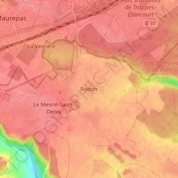
名前:Rodonの地形図、標高、地勢。
平均標高:167 m
最低標高:112 m
最大標高:179 m
寄付をします
次の冒険に備えよう:
Amazonアソシエイトとして、このサイトは対象となる購入から手数料を受け取りますが、お客様の負担はありません。
その他の地形図
地図をクリックすると、その地形、その標高、その地勢が表示されます。
Versailles
France > Ile-de-France > Yvelines
Versailles is located 17.1 km (10.6 mi) west-southwest from the centre of Paris. The city sits on an elevated plateau, 130 to 140 metres (430 to 460 ft) above sea level (whereas the elevation of the centre of Paris is only 33 m (108 ft) above sea level), surrounded by wooded hills: in the north the forests of…
平均標高:142 m
Montfort-l'Amaury
France > Ile-de-France > Yvelines
Montfort-l'Amaury lies north of the Rambouillet Forest. It is located at the foot of low hills, at about 130 m above sea level. Montfort-l’Amaury has a land area of about 5.71 km², with an elevation of approximately 130 meters above sea level. As of the latest legal census, the population is around 2,790…
平均標高:152 m
寄付をします
次の冒険に備えよう:
Amazonアソシエイトとして、このサイトは対象となる購入から手数料を受け取りますが、お客様の負担はありません。
寄付をします
次の冒険に備えよう:
Amazonアソシエイトとして、このサイトは対象となる購入から手数料を受け取りますが、お客様の負担はありません。
寄付をします
次の冒険に備えよう:
Amazonアソシエイトとして、このサイトは対象となる購入から手数料を受け取りますが、お客様の負担はありません。
寄付をします
次の冒険に備えよう:
Amazonアソシエイトとして、このサイトは対象となる購入から手数料を受け取りますが、お客様の負担はありません。
Versailles
France > Ile-de-France > Yvelines
Versailles is located 17.1 km (10.6 mi) west-southwest from the centre of Paris. The city sits on an elevated plateau, 130 to 140 metres (430 to 460 ft) above sea level (whereas the elevation of the centre of Paris is only 33 m (108 ft) above sea level), surrounded by wooded hills: in the north the forests of…
平均標高:142 m
Le Vésinet
France > Ile-de-France > Yvelines
The terrain is an alluvial plain ranging in altitude from 28 meters near Le Pecq to 45 meters at the end of the Route de Montesson, with a gentle slope from northeast to southwest.
平均標高:37 m
寄付をします
次の冒険に備えよう:
Amazonアソシエイトとして、このサイトは対象となる購入から手数料を受け取りますが、お客様の負担はありません。
Versailles
France > Ile-de-France > Yvelines
Versailles is located 17.1 km (10.6 mi) west-southwest from the centre of Paris. The city sits on an elevated plateau, 130 to 140 metres (430 to 460 ft) above sea level (whereas the elevation of the centre of Paris is only 33 m (108 ft) above sea level), surrounded by wooded hills: in the north the forests of…
平均標高:142 m
寄付をします
次の冒険に備えよう:
Amazonアソシエイトとして、このサイトは対象となる購入から手数料を受け取りますが、お客様の負担はありません。
寄付をします
次の冒険に備えよう:
Amazonアソシエイトとして、このサイトは対象となる購入から手数料を受け取りますが、お客様の負担はありません。
Buc
France > Ile-de-France > Yvelines
The old town lies in the valley of the River Bièvre at an elevation of around 100 m above sea level. Most of Buc's residential districts have been built on the plateau de Saclay, some 50 m higher.
平均標高:151 m
寄付をします
次の冒険に備えよう:
Amazonアソシエイトとして、このサイトは対象となる購入から手数料を受け取りますが、お客様の負担はありません。
寄付をします
次の冒険に備えよう:
Amazonアソシエイトとして、このサイトは対象となる購入から手数料を受け取りますが、お客様の負担はありません。
Versailles
France > Ile-de-France > Yvelines
Versailles is located 17.1 km (10.6 mi) west-southwest from the centre of Paris. The city sits on an elevated plateau, 130 to 140 metres (425 to 460 ft) above sea-level (whereas the elevation of the centre of Paris is only 33 m (108 ft) above sea level), surrounded by wooded hills: in the north the forests of…
平均標高:142 m
寄付をします
次の冒険に備えよう:
Amazonアソシエイトとして、このサイトは対象となる購入から手数料を受け取りますが、お客様の負担はありません。
寄付をします
次の冒険に備えよう:
Amazonアソシエイトとして、このサイトは対象となる購入から手数料を受け取りますが、お客様の負担はありません。
寄付をします
次の冒険に備えよう:
Amazonアソシエイトとして、このサイトは対象となる購入から手数料を受け取りますが、お客様の負担はありません。
Buc
France > Ile-de-France > Yvelines
The old town lies in the valley of the River Bièvre at an elevation of around 100 m above sea level. Most of Buc's residential districts have been built on the plateau de Saclay, some 50 m higher.
平均標高:151 m