
寄付をします
次の冒険に備えよう:
Amazonアソシエイトとして、このサイトは対象となる購入から手数料を受け取りますが、お客様の負担はありません。
Monifieth地形図
地図をクリックすると標高が表示されます。
寄付をします
次の冒険に備えよう:
Amazonアソシエイトとして、このサイトは対象となる購入から手数料を受け取りますが、お客様の負担はありません。
Monifieth
The name "Monifieth" likely derives from the Gaelic "Moine Feith", "Bogstream of the marsh/moss". Previous suggestions that it comes from "Monadh Fieth" meaning "hill of the deer" make little sense. "Monadh" would mean a large upland mountainous area, which(given that the town is many miles from the highlands) is the exact opposite of Monifieths topography. An alternative etymology Monaich Fother, 'Monks' Land' has been suggested, which holds some appeal due to Monifieth's early status as a possession of the Céli Dé monastic order.
寄付をします
次の冒険に備えよう:
Amazonアソシエイトとして、このサイトは対象となる購入から手数料を受け取りますが、お客様の負担はありません。
この地図について
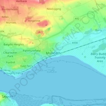
名前:Monifiethの地形図、標高、地勢。
場所:Monifieth, Angus, Scotland, DD5 4AA, United Kingdom (56.44180 -2.85801 56.52180 -2.77801)
平均標高:29 m
最低標高:-1 m
最大標高:145 m
寄付をします
次の冒険に備えよう:
Amazonアソシエイトとして、このサイトは対象となる購入から手数料を受け取りますが、お客様の負担はありません。