
寄付をします
次の冒険に備えよう:
Amazonアソシエイトとして、このサイトは対象となる購入から手数料を受け取りますが、お客様の負担はありません。
Morelia地形図
地図をクリックすると標高が表示されます。
寄付をします
次の冒険に備えよう:
Amazonアソシエイトとして、このサイトは対象となる購入から手数料を受け取りますが、お客様の負担はありません。
Morelia
Under the Köppen climate classification, Morelia has a subtropical highland climate (abbreviated Cwb on climate maps), with warm-to-hot days and cool nights year round due to its high elevation. Most precipitation falls during the summer monsoon season from June to September. Average monthly temperatures are between 14 and 22 °C (57 and 72 °F), with maximum temperatures of 38.3 °C (100.9 °F) in the summer of 1998 and the lowest temperature of −5.2 °C (22.6 °F) in January 1985.
寄付をします
次の冒険に備えよう:
Amazonアソシエイトとして、このサイトは対象となる購入から手数料を受け取りますが、お客様の負担はありません。
この地図について
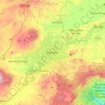
名前:Moreliaの地形図、標高、地勢。
場所:Morelia, Michoacán, 58000, Mexico (19.54271 -101.35238 19.86271 -101.03238)
平均標高:2,071 m
最低標高:1,323 m
最大標高:2,989 m
寄付をします
次の冒険に備えよう:
Amazonアソシエイトとして、このサイトは対象となる購入から手数料を受け取りますが、お客様の負担はありません。