
寄付をします
次の冒険に備えよう:
Amazonアソシエイトとして、このサイトは対象となる購入から手数料を受け取りますが、お客様の負担はありません。
Bacup地形図
地図をクリックすると標高が表示されます。
寄付をします
次の冒険に備えよう:
Amazonアソシエイトとして、このサイトは対象となる購入から手数料を受け取りますが、お客様の負担はありません。
Bacup
The geology and topography of the village lent itself to urbanisation and domestic industries; primitive weavers' cottages, coal pits and stone quarries were propelled by Bacup's natural supply of water power in the Early Modern period. The adoption of the factory system, which developed into the Industrial Revolution, enabled the transformation of Bacup from a small rural village into a mill town, populated by an influx of families attracted by Bacup's cotton mills, civic amenities and regional railway network. Locally sourced coal provided the fuel for industrial-scale quarrying, cotton spinning and shoemaking operations, stimulating the local economy. Bacup received a charter of incorporation in 1882, giving it honorific borough status and its own elected town government, consisting of a mayor, aldermen and councillors to oversee local affairs.
寄付をします
次の冒険に備えよう:
Amazonアソシエイトとして、このサイトは対象となる購入から手数料を受け取りますが、お客様の負担はありません。
この地図について
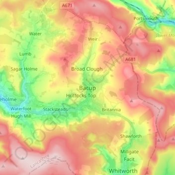
名前:Bacupの地形図、標高、地勢。
平均標高:337 m
最低標高:180 m
最大標高:477 m
寄付をします
次の冒険に備えよう:
Amazonアソシエイトとして、このサイトは対象となる購入から手数料を受け取りますが、お客様の負担はありません。
その他の地形図
地図をクリックすると、その地形、その標高、その地勢が表示されます。
Cowm Reservoir
United Kingdom > England > Lancashire > Borough of Rossendale > Whitworth > Shawforth
平均標高:302 m