
寄付をします
次の冒険に備えよう:
Amazonアソシエイトとして、このサイトは対象となる購入から手数料を受け取りますが、お客様の負担はありません。
Austin地形図
地図をクリックすると標高が表示されます。
寄付をします
次の冒険に備えよう:
Amazonアソシエイトとして、このサイトは対象となる購入から手数料を受け取りますが、お客様の負担はありません。
Austin
Austin is an unincorporated small town in, and former county seat of, Lander County, Nevada, United States. In 2020, the census-designated place of Austin had a population of 167. It is located on the western slopes of the Toiyabe Range at an elevation of 6,575 feet (2,004 m). U.S. Route 50 passes through the town.
寄付をします
次の冒険に備えよう:
Amazonアソシエイトとして、このサイトは対象となる購入から手数料を受け取りますが、お客様の負担はありません。
この地図について
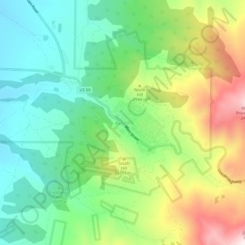
名前:Austinの地形図、標高、地勢。
場所:Austin, Lander County, Nevada, United States (39.47326 -117.08954 39.51326 -117.04954)
平均標高:2,076 m
最低標高:1,841 m
最大標高:2,464 m
寄付をします
次の冒険に備えよう:
Amazonアソシエイトとして、このサイトは対象となる購入から手数料を受け取りますが、お客様の負担はありません。
その他の地形図
地図をクリックすると、その地形、その標高、その地勢が表示されます。
Battle Mountain
United States > Nevada > Lander County > Battle Mountain
Battle Mountain's climate is cool semi-arid (Köppen climate classification BSk), receiving just enough precipitation to avoid arid classification. Due to aridity and high elevation, the area commonly experiences large diurnal temperature variation, particularly in summer, when it averages almost 45 °F or 25…
平均標高:1,378 m
Battle Mountain
United States > Nevada > Lander County
Battle Mountain's climate is cool semi-arid (Köppen climate classification BSk), receiving just enough precipitation to avoid arid classification. Due to aridity and high elevation, the area commonly experiences large diurnal temperature variation, particularly in summer, when it averages almost 45 °F or 25…
平均標高:1,376 m