
寄付をします
次の冒険に備えよう:
Amazonアソシエイトとして、このサイトは対象となる購入から手数料を受け取りますが、お客様の負担はありません。
Kula地形図
地図をクリックすると標高が表示されます。
寄付をします
次の冒険に備えよう:
Amazonアソシエイトとして、このサイトは対象となる購入から手数料を受け取りますが、お客様の負担はありません。
Kula
Kula is a district and census-designated place (CDP) of Maui, Hawaii, that stretches across the "up-country", the western-facing slopes of Haleakalā, from Makawao to Kanaio. Most of the residential areas lie between about 500 to 1,100 m (1,600 to 3,600 ft) in elevation. The district has traditionally been where full-time residents prefer to live, as distinct from the generally hotter and busier, more tourism-oriented towns near sea level, such as Kihei and Lahaina. The population of the Kula CDP at the 2020 Census was 6,942, while the larger Kula Census County Division, which includes the communities of Keokea, Wailea, and Makena, had a population of 12,864.
寄付をします
次の冒険に備えよう:
Amazonアソシエイトとして、このサイトは対象となる購入から手数料を受け取りますが、お客様の負担はありません。
この地図について
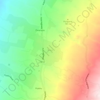
名前:Kulaの地形図、標高、地勢。
場所:Kula, Maui County, Hawaii, 96790, United States (20.77203 -156.34371 20.81203 -156.30371)
平均標高:740 m
最低標高:473 m
最大標高:1,089 m
寄付をします
次の冒険に備えよう:
Amazonアソシエイトとして、このサイトは対象となる購入から手数料を受け取りますが、お客様の負担はありません。