
寄付をします
次の冒険に備えよう:
Amazonアソシエイトとして、このサイトは対象となる購入から手数料を受け取りますが、お客様の負担はありません。
Nayarit地形図
地図をクリックすると標高が表示されます。
寄付をします
次の冒険に備えよう:
Amazonアソシエイトとして、このサイトは対象となる購入から手数料を受け取りますが、お客様の負担はありません。
この地図について
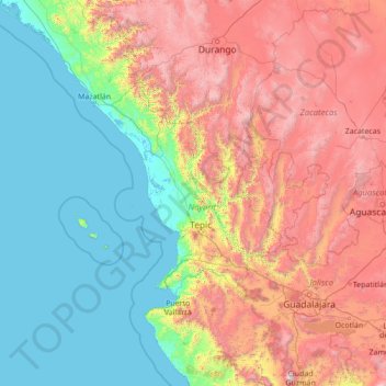
名前:Nayaritの地形図、標高、地勢。
場所:Nayarit, Mexico (19.44000 -107.56000 24.56000 -102.44000)
平均標高:1,039 m
最低標高:-2 m
最大標高:3,964 m
寄付をします
次の冒険に備えよう:
Amazonアソシエイトとして、このサイトは対象となる購入から手数料を受け取りますが、お客様の負担はありません。
その他の地形図
地図をクリックすると、その地形、その標高、その地勢が表示されます。
寄付をします
次の冒険に備えよう:
Amazonアソシエイトとして、このサイトは対象となる購入から手数料を受け取りますが、お客様の負担はありません。
San Pedro Lagunillas
Most of the municipality belongs to a volcanic zone. The main elevations are "Cerro Grande"(2,000 meters), "Cerro Tetillas" (1,760 meters), "Cerro La Palma" (1,740 meters), "Cerro Estiladero" (1,600 meters), "Cerro El Carretón" (1,580 meters), and the extinct volcano of "Tepetiltic" (1,500 meters).
平均標高:1,099 m
寄付をします
次の冒険に備えよう:
Amazonアソシエイトとして、このサイトは対象となる購入から手数料を受け取りますが、お客様の負担はありません。
寄付をします
次の冒険に備えよう:
Amazonアソシエイトとして、このサイトは対象となる購入から手数料を受け取りますが、お客様の負担はありません。