
寄付をします
次の冒険に備えよう:
Amazonアソシエイトとして、このサイトは対象となる購入から手数料を受け取りますが、お客様の負担はありません。
Mount Calliope地形図
地図をクリックすると標高が表示されます。
寄付をします
次の冒険に備えよう:
Amazonアソシエイトとして、このサイトは対象となる購入から手数料を受け取りますが、お客様の負担はありません。
この地図について
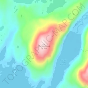
名前:Mount Calliopeの地形図、標高、地勢。
平均標高:102 m
最低標高:-3 m
最大標高:400 m
寄付をします
次の冒険に備えよう:
Amazonアソシエイトとして、このサイトは対象となる購入から手数料を受け取りますが、お客様の負担はありません。
その他の地形図
地図をクリックすると、その地形、その標高、その地勢が表示されます。
Kerguelen Archipelago
France > French Southern and Antarctic Lands
The highest point is Mont Ross in the Gallieni Massif, which rises along the southern coast of the island and has an elevation of 1,850 metres (6,070 ft). The Cook Ice Cap (French: Calotte Glaciaire Cook), France's largest glacier with an area of about 403 km2 (156 sq mi), lies on the west-central part of the…
平均標高:38 m
寄付をします
次の冒険に備えよう:
Amazonアソシエイトとして、このサイトは対象となる購入から手数料を受け取りますが、お客様の負担はありません。
Kerguelen Archipelago
France > French Southern and Antarctic Lands
The highest point is Mont Ross in the Gallieni Massif, which rises along the southern coast of the island and has an elevation of 1,850 metres (6,070 ft). The Cook Ice Cap (French: Calotte Glaciaire Cook), France's largest glacier with an area of about 403 km2 (156 sq mi), lies on the west-central part of the…
平均標高:38 m
寄付をします
次の冒険に備えよう:
Amazonアソシエイトとして、このサイトは対象となる購入から手数料を受け取りますが、お客様の負担はありません。
Kerguelen Archipelago
France > French Southern and Antarctic Lands
The highest point is Mont Ross in the Gallieni Massif, which rises along the southern coast of the island and has an elevation of 1,850 metres (6,070 ft). The Cook Ice Cap (French: Calotte Glaciaire Cook), France's largest glacier with an area of about 403 km2 (156 sq mi), lies on the west-central part of the…
平均標高:38 m
寄付をします
次の冒険に備えよう:
Amazonアソシエイトとして、このサイトは対象となる購入から手数料を受け取りますが、お客様の負担はありません。
Possession Island
France > French Southern and Antarctic Lands
The island has been identified as an Important Bird Area (IBA) by BirdLife International as a breeding site for seabirds, of which there are at least 26 breeding species. Birds nesting in relatively large numbers include king, northern rockhopper and macaroni penguins, wandering, sooty and light-mantled…
平均標高:13 m