
このサイトをサポートしていただきありがとうございます ❤️
寄付をします
寄付をします
次の冒険に備えよう:
Amazonアソシエイトとして、このサイトは対象となる購入から手数料を受け取りますが、お客様の負担はありません。
Tembilahan地形図
地図をクリックすると標高が表示されます。
このサイトをサポートしていただきありがとうございます ❤️
寄付をします
寄付をします
次の冒険に備えよう:
Amazonアソシエイトとして、このサイトは対象となる購入から手数料を受け取りますが、お客様の負担はありません。
Tembilahan
The soil conditions of the area is mostly composed of peat soil and stream sediment and marshes. The altitude of the District's Government's Centre is from 1 to 4 metres. On the banks of the rivers and in the estuaries trenches there are many plants that grow, such as Nipah trees.
このサイトをサポートしていただきありがとうございます ❤️
寄付をします
寄付をします
次の冒険に備えよう:
Amazonアソシエイトとして、このサイトは対象となる購入から手数料を受け取りますが、お客様の負担はありません。
この地図について
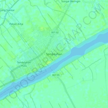
名前:Tembilahanの地形図、標高、地勢。
場所:Tembilahan, Indragiri Hilir, Riau, Sumatra, 29281, Indonesia (-0.36147 103.12175 -0.28147 103.20175)
平均標高:4 m
最低標高:0 m
最大標高:8 m
このサイトをサポートしていただきありがとうございます ❤️
寄付をします
寄付をします
次の冒険に備えよう:
Amazonアソシエイトとして、このサイトは対象となる購入から手数料を受け取りますが、お客様の負担はありません。
その他の地形図
地図をクリックすると、その地形、その標高、その地勢が表示されます。