
寄付をします
次の冒険に備えよう:
Amazonアソシエイトとして、このサイトは対象となる購入から手数料を受け取りますが、お客様の負担はありません。
Mount David地形図
地図をクリックすると標高が表示されます。
寄付をします
次の冒険に備えよう:
Amazonアソシエイトとして、このサイトは対象となる購入から手数料を受け取りますが、お客様の負担はありません。
Mount David
Mount David is a prominent 7,420-foot (2,260-metre) mountain summit located in Chelan County of Washington state. The mountain is situated in the Glacier Peak Wilderness, on land managed by the Okanogan-Wenatchee National Forest. Mount David is the highest point of Wenatchee Ridge, a subrange which also includes Indian Head Peak, Whittier Peak, Mount Saul, and Mount Jonathan. Its nearest higher neighbor is Bandit Peak, 5.69 mi (9.16 km) to the east-northeast. Precipitation runoff from Mount David drains into tributaries of the White River. Although modest in elevation, relief is significant since Mt. David rises 5,100 feet above the White River Valley in two miles. This peak was named for the biblical David by Albert Hale Sylvester, a pioneer surveyor, explorer, topographer, and forest supervisor in the Cascades who named thousands of natural features. This mountain can be climbed via the strenuous seven-mile Mount David Trail with over 5,000 feet of elevation gain.
寄付をします
次の冒険に備えよう:
Amazonアソシエイトとして、このサイトは対象となる購入から手数料を受け取りますが、お客様の負担はありません。
この地図について
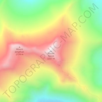
名前:Mount Davidの地形図、標高、地勢。
場所:Mount David, Chelan County, Washington, United States (47.96284 -120.98987 47.96294 -120.98977)
平均標高:1,736 m
最低標高:1,247 m
最大標高:2,224 m
寄付をします
次の冒険に備えよう:
Amazonアソシエイトとして、このサイトは対象となる購入から手数料を受け取りますが、お客様の負担はありません。
その他の地形図
地図をクリックすると、その地形、その標高、その地勢が表示されます。
Lake Chelan
United States > Washington > Chelan County > Chelan
Lake Chelan (/ʃəˈlæn/ shə-LAN) is a narrow, 50.5 mi (81.3 km) long lake in Chelan County, north-central Washington state, U.S. It is an overdeepened lake and resembles a fjord, with an average width of 1.3 mi (2.1 km). Near its upper end, the lake surface lies more than 6,600 ft (2,000 m) below peaks less…
平均標高:1,358 m