
寄付をします
次の冒険に備えよう:
Amazonアソシエイトとして、このサイトは対象となる購入から手数料を受け取りますが、お客様の負担はありません。
Peak Hill地形図
地図をクリックすると標高が表示されます。
寄付をします
次の冒険に備えよう:
Amazonアソシエイトとして、このサイトは対象となる購入から手数料を受け取りますが、お客様の負担はありません。
この地図について
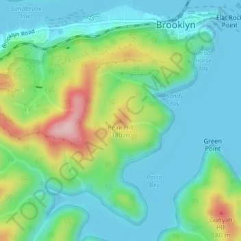
名前:Peak Hillの地形図、標高、地勢。
平均標高:58 m
最低標高:-1 m
最大標高:209 m
寄付をします
次の冒険に備えよう:
Amazonアソシエイトとして、このサイトは対象となる購入から手数料を受け取りますが、お客様の負担はありません。
その他の地形図
地図をクリックすると、その地形、その標高、その地勢が表示されます。
寄付をします
次の冒険に備えよう:
Amazonアソシエイトとして、このサイトは対象となる購入から手数料を受け取りますが、お客様の負担はありません。
寄付をします
次の冒険に備えよう:
Amazonアソシエイトとして、このサイトは対象となる購入から手数料を受け取りますが、お客様の負担はありません。
Lane Cove National Park
Australia > New South Wales > Sydney
The park includes areas of land which are part of Ku-ring-gai, Ryde, and Hornsby local government areas with small areas of the park in Willoughby, Lane Cove and Hunter's Hill local government areas on the banks of the lower reaches of the river. The park is surrounded on all sides by developed suburban areas…
平均標高:81 m
Mount Kuring-Gai
Australia > New South Wales > Sydney
Mount Kuring-gai is located approximately 7 km north of Hornsby. Its neighbouring suburbs are Berowra to the north, and Mount Colah to the south. Surrounded by bushland, it is bordered by Ku-ring-gai Chase National Park on the eastern side and by Berowra Valley Regional Park on the western side. There are…
平均標高:133 m
寄付をします
次の冒険に備えよう:
Amazonアソシエイトとして、このサイトは対象となる購入から手数料を受け取りますが、お客様の負担はありません。
寄付をします
次の冒険に備えよう:
Amazonアソシエイトとして、このサイトは対象となる購入から手数料を受け取りますが、お客様の負担はありません。
寄付をします
次の冒険に備えよう:
Amazonアソシエイトとして、このサイトは対象となる購入から手数料を受け取りますが、お客様の負担はありません。
Ku-ring-gai Chase National Park
Australia > New South Wales > Sydney
Ku-ring-gai Chase is part of the Hornsby Plateau, a massive block of sandstone tilting upwards to the north. The park comprises a plateau with an elevation of generally 150–200 m above sea level. Between 250 and 200 million years ago, sand silt and mud was deposited by rivers across flood plains. These…
平均標高:83 m
寄付をします
次の冒険に備えよう:
Amazonアソシエイトとして、このサイトは対象となる購入から手数料を受け取りますが、お客様の負担はありません。
寄付をします
次の冒険に備えよう:
Amazonアソシエイトとして、このサイトは対象となる購入から手数料を受け取りますが、お客様の負担はありません。
寄付をします
次の冒険に備えよう:
Amazonアソシエイトとして、このサイトは対象となる購入から手数料を受け取りますが、お客様の負担はありません。
寄付をします
次の冒険に備えよう:
Amazonアソシエイトとして、このサイトは対象となる購入から手数料を受け取りますが、お客様の負担はありません。
寄付をします
次の冒険に備えよう:
Amazonアソシエイトとして、このサイトは対象となる購入から手数料を受け取りますが、お客様の負担はありません。
寄付をします
次の冒険に備えよう:
Amazonアソシエイトとして、このサイトは対象となる購入から手数料を受け取りますが、お客様の負担はありません。
寄付をします
次の冒険に備えよう:
Amazonアソシエイトとして、このサイトは対象となる購入から手数料を受け取りますが、お客様の負担はありません。
寄付をします
次の冒険に備えよう:
Amazonアソシエイトとして、このサイトは対象となる購入から手数料を受け取りますが、お客様の負担はありません。
寄付をします
次の冒険に備えよう:
Amazonアソシエイトとして、このサイトは対象となる購入から手数料を受け取りますが、お客様の負担はありません。
寄付をします
次の冒険に備えよう:
Amazonアソシエイトとして、このサイトは対象となる購入から手数料を受け取りますが、お客様の負担はありません。
Woodford
Australia > New South Wales > Sydney
Woodford is a village in the Blue Mountains in New South Wales, Australia, about 90 kilometres west of Sydney. Its elevation is 609 metres (1,998 ft) above sea level. It is situated on the Great Western Highway and has a railway station (opened in 1868 as Buss's Platform) on the Main Western railway line…
平均標高:544 m
寄付をします
次の冒険に備えよう:
Amazonアソシエイトとして、このサイトは対象となる購入から手数料を受け取りますが、お客様の負担はありません。
寄付をします
次の冒険に備えよう:
Amazonアソシエイトとして、このサイトは対象となる購入から手数料を受け取りますが、お客様の負担はありません。
寄付をします
次の冒険に備えよう:
Amazonアソシエイトとして、このサイトは対象となる購入から手数料を受け取りますが、お客様の負担はありません。
Smithfield
Australia > New South Wales > Sydney
Established in 1836, Smithfield was the first major settlement of the Fairfield LGA. The original 1838 summary plan of Smithfield shows the suburb laid out in a grid pattern with most of the streets having the same names as they do today. Its altitude ranges from 21 to 48 m (69 to 157 ft) above sea level.…
平均標高:33 m
寄付をします
次の冒険に備えよう:
Amazonアソシエイトとして、このサイトは対象となる購入から手数料を受け取りますが、お客様の負担はありません。
寄付をします
次の冒険に備えよう:
Amazonアソシエイトとして、このサイトは対象となる購入から手数料を受け取りますが、お客様の負担はありません。
寄付をします
次の冒険に備えよう:
Amazonアソシエイトとして、このサイトは対象となる購入から手数料を受け取りますが、お客様の負担はありません。
寄付をします
次の冒険に備えよう:
Amazonアソシエイトとして、このサイトは対象となる購入から手数料を受け取りますが、お客様の負担はありません。
寄付をします
次の冒険に備えよう:
Amazonアソシエイトとして、このサイトは対象となる購入から手数料を受け取りますが、お客様の負担はありません。
Gregory Hills
Australia > New South Wales > Sydney
Gregory Hills is a suburb of Sydney in the state of New South Wales, Australia in Camden Council. The suburb was assigned on 1 August 2008. The suburb was named from the topography of the local area and from the original St Gregory's Chapel on the Marist Brothers land.
平均標高:109 m
寄付をします
次の冒険に備えよう:
Amazonアソシエイトとして、このサイトは対象となる購入から手数料を受け取りますが、お客様の負担はありません。
Cammeray
Australia > New South Wales > Sydney
Prior to the 1920s, the suburb was known as Suspension Bridge reflecting the now Long Gully Bridge that joined Northbridge to Cammeray. Cammeray was slow to develop mainly due to its steep topography and remoteness from transport.
平均標高:66 m
寄付をします
次の冒険に備えよう:
Amazonアソシエイトとして、このサイトは対象となる購入から手数料を受け取りますが、お客様の負担はありません。