
寄付をします
次の冒険に備えよう:
Amazonアソシエイトとして、このサイトは対象となる購入から手数料を受け取りますが、お客様の負担はありません。
Haliburton地形図
地図をクリックすると標高が表示されます。
寄付をします
次の冒険に備えよう:
Amazonアソシエイトとして、このサイトは対象となる購入から手数料を受け取りますが、お客様の負担はありません。
この地図について
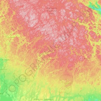
名前:Haliburtonの地形図、標高、地勢。
場所:Haliburton, Ontario, Canada (44.51254 -79.15481 45.79254 -77.87481)
平均標高:358 m
最低標高:172 m
最大標高:566 m
寄付をします
次の冒険に備えよう:
Amazonアソシエイトとして、このサイトは対象となる購入から手数料を受け取りますが、お客様の負担はありません。
その他の地形図
地図をクリックすると、その地形、その標高、その地勢が表示されます。
Ottawa
Ottawa, the capital city of Canada, is situated on the south bank of the Ottawa River at the confluence with the Rideau River. The city's topography is characterized by gently rolling terrain with elevations ranging from approximately 44 meters (144 feet) above sea level at the Ottawa River to its highest…
平均標高:105 m
Mississauga
Canada > Ontario > Peel Region
The shoreline of former Glacial Lake Iroquois roughly follows the Dundas Street alignment, although it is not noticeable in some places but is more prominent in others, such as the site of the former brickyard (Shoreline Dr. near Mavis Rd.), the ancient shoreline promenteau affords a clear view of downtown…
平均標高:151 m
寄付をします
次の冒険に備えよう:
Amazonアソシエイトとして、このサイトは対象となる購入から手数料を受け取りますが、お客様の負担はありません。
Toronto
Despite its deep ravines, Toronto is not remarkably hilly, but its elevation does increase steadily away from the lake. Elevation differences range from 76.5 metres (251 ft) above sea level at the Lake Ontario shore to 209 m (686 ft) ASL near the York University grounds in the city's north end at the…
平均標高:139 m
寄付をします
次の冒険に備えよう:
Amazonアソシエイトとして、このサイトは対象となる購入から手数料を受け取りますが、お客様の負担はありません。
Kitchener
Canada > Ontario > Region of Waterloo
Kitchener is located in Southwestern Ontario, in the Saint Lawrence Lowlands. This geological and climatic region has wet-climate soils and deciduous forests. Situated in the Grand River Valley, the area is generally above 300 m (1,000 ft) in elevation.
平均標高:336 m
Lake Ontario
Lake Ontario is the easternmost of the Great Lakes and the smallest in surface area (7,340 sq mi, 18,960 km2), although it exceeds Lake Erie in volume (393 cu mi, 1,639 km3). It is the 13th largest lake in the world. When its islands are included, the lake's shoreline is 712 miles (1,146 km) long. As the last…
平均標高:214 m
寄付をします
次の冒険に備えよう:
Amazonアソシエイトとして、このサイトは対象となる購入から手数料を受け取りますが、お客様の負担はありません。
Lake Nipissing
Canada > Ontario > Nipissing District
Lake Nipissing (/ˈnɪpəsɪŋ/; French: lac Nipissing, Ojibwe: Gichi-nibiinsing-zaaga’igan) is a lake in the Canadian province of Ontario. It has a surface area of 873.3 km2 (337.2 sq mi), a mean elevation of 196 m (643 ft) above sea level, and is located between the Ottawa River and Georgian Bay. Lake…
平均標高:272 m
Toronto
Despite its deep ravines, Toronto is not remarkably hilly, but its elevation does increase steadily away from the lake. Elevation differences range from 76.5 metres (251 ft) above sea level at the Lake Ontario shore to 209 m (686 ft) above sea level near the York University grounds in the city's north end at…
平均標高:139 m
Eastern Ontario
Along the extreme western edge of Eastern Ontario is a continuation of the Laurentian Highlands, known as the Opeongo Hills, and they contain some of the highest elevations in Southern Ontario. They stretch into the northern portions of Central Ontario, near Algonquin Provincial Park.
平均標高:243 m
寄付をします
次の冒険に備えよう:
Amazonアソシエイトとして、このサイトは対象となる購入から手数料を受け取りますが、お客様の負担はありません。
寄付をします
次の冒険に備えよう:
Amazonアソシエイトとして、このサイトは対象となる購入から手数料を受け取りますが、お客様の負担はありません。
St. Catharines
Canada > Ontario > Niagara Region
The most defining transportation icon of St. Catharines is the Welland Canal, a ship canal that runs 43.4 kilometres (27.0 mi), passing through the city. Four of its locks are within city boundaries. The canal allows shipping vessels to traverse the 99.5-metre (326.5 ft) drop in altitude from Lake Erie to Lake…
平均標高:103 m
Pickering
Canada > Ontario > Durham Region
The city covers an area of 231 square kilometres (89 sq mi) with an elevation of 89 metres (292 ft).
平均標高:170 m
Hamilton
The airport's open, rural location and higher altitude results in lower temperatures, generally windier conditions, and higher snowfall amounts than lower, built-up areas of the city. The highest temperature ever recorded in Hamilton was 41.1 °C (106 °F) on July 14, 1868. The coldest temperature ever…
平均標高:187 m
寄付をします
次の冒険に備えよう:
Amazonアソシエイトとして、このサイトは対象となる購入から手数料を受け取りますが、お客様の負担はありません。
寄付をします
次の冒険に備えよう:
Amazonアソシエイトとして、このサイトは対象となる購入から手数料を受け取りますが、お客様の負担はありません。
Scarborough
Topographically, Scarborough is dominated by two watersheds, Highland Creek and the Rouge River. Highland Creek lies almost entirely within Scarborough and occupies approximately 70% of its total area. It occupies the western half of Scarborough, while the Rouge River flows through the eastern portion. Both of…
平均標高:138 m
寄付をします
次の冒険に備えよう:
Amazonアソシエイトとして、このサイトは対象となる購入から手数料を受け取りますが、お客様の負担はありません。
寄付をします
次の冒険に備えよう:
Amazonアソシエイトとして、このサイトは対象となる購入から手数料を受け取りますが、お客様の負担はありません。
寄付をします
次の冒険に備えよう:
Amazonアソシエイトとして、このサイトは対象となる購入から手数料を受け取りますが、お客様の負担はありません。
Deep River
Canada > Ontario > Renfrew County
John Bland, an architecture professor at McGill University, developed the town's first master plan in 1944. Bland located the town between the existing Highway 17 and the Ottawa River. He designed a system of streets which generally followed the contours of the area's topography. Residential neighborhoods…
平均標高:169 m
寄付をします
次の冒険に備えよう:
Amazonアソシエイトとして、このサイトは対象となる購入から手数料を受け取りますが、お客様の負担はありません。
寄付をします
次の冒険に備えよう:
Amazonアソシエイトとして、このサイトは対象となる購入から手数料を受け取りますが、お客様の負担はありません。
寄付をします
次の冒険に備えよう:
Amazonアソシエイトとして、このサイトは対象となる購入から手数料を受け取りますが、お客様の負担はありません。
寄付をします
次の冒険に備えよう:
Amazonアソシエイトとして、このサイトは対象となる購入から手数料を受け取りますが、お客様の負担はありません。
Sarnia
Canada > Ontario > Lambton County
Sarnia is located on the eastern shore of Lake Huron at its extreme southern point, where it flows into the St. Clair River. Most of the surrounding area is flat, and the elevation ranges from 169 metres (554 ft) and 281 metres (922 ft) above sea level. The soil mostly comprises clay. Despite this high…
平均標高:186 m
寄付をします
次の冒険に備えよう:
Amazonアソシエイトとして、このサイトは対象となる購入から手数料を受け取りますが、お客様の負担はありません。
寄付をします
次の冒険に備えよう:
Amazonアソシエイトとして、このサイトは対象となる購入から手数料を受け取りますが、お客様の負担はありません。
寄付をします
次の冒険に備えよう:
Amazonアソシエイトとして、このサイトは対象となる購入から手数料を受け取りますが、お客様の負担はありません。
Barrie
On September 7, 1977, a private aircraft, flown by "Army" Hollingsworth, dropped altitude to 500 feet (152 m) in dense fog and struck CKVR's 1,000-foot (305 m) transmitter tower, killing all five people aboard the plane and destroying the tower and antenna. The station's 225-foot (69 m) auxiliary tower was…
平均標高:265 m
寄付をします
次の冒険に備えよう:
Amazonアソシエイトとして、このサイトは対象となる購入から手数料を受け取りますが、お客様の負担はありません。
lac Seul
Canada > Ontario > Kenora District > Unorganized Kenora District
Lac Seul is a large, crescent shaped reservoir in Kenora District, northwestern Ontario, Canada. It is approximately 241 km (150 mi) long. It has a maximum (regulated) depth of 47.2 m, with a surface elevation of 357 m above sea level. Its level is raised in the summer and then drawn down in the winter months…
平均標高:374 m
寄付をします
次の冒険に備えよう:
Amazonアソシエイトとして、このサイトは対象となる購入から手数料を受け取りますが、お客様の負担はありません。
Newmarket
Canada > Ontario > York Region
Newmarket's geographical coordinates are 44.05°N, 79.46°W, and its elevation above sea level is 252 m. It has an area of 38.33 km². The town is bounded on the south by Aurora, on the west by King, on the north by East Gwillimbury and on the east by Whitchurch–Stouffville.
平均標高:270 m
寄付をします
次の冒険に備えよう:
Amazonアソシエイトとして、このサイトは対象となる購入から手数料を受け取りますが、お客様の負担はありません。
寄付をします
次の冒険に備えよう:
Amazonアソシエイトとして、このサイトは対象となる購入から手数料を受け取りますが、お客様の負担はありません。
寄付をします
次の冒険に備えよう:
Amazonアソシエイトとして、このサイトは対象となる購入から手数料を受け取りますが、お客様の負担はありません。
寄付をします
次の冒険に備えよう:
Amazonアソシエイトとして、このサイトは対象となる購入から手数料を受け取りますが、お客様の負担はありません。
寄付をします
次の冒険に備えよう:
Amazonアソシエイトとして、このサイトは対象となる購入から手数料を受け取りますが、お客様の負担はありません。
寄付をします
次の冒険に備えよう:
Amazonアソシエイトとして、このサイトは対象となる購入から手数料を受け取りますが、お客様の負担はありません。