
寄付をします
次の冒険に備えよう:
Amazonアソシエイトとして、このサイトは対象となる購入から手数料を受け取りますが、お客様の負担はありません。
Tha Ton地形図
地図をクリックすると標高が表示されます。
寄付をします
次の冒険に備えよう:
Amazonアソシエイトとして、このサイトは対象となる購入から手数料を受け取りますが、お客様の負担はありません。
Tha Ton
The village is overlooked by a hilltop Buddhist temple known as Wat Tha Ton. The temple complex includes four huge statues of the Buddha, two in typical Thai-style and two showing Chinese influence. One of these, the standing Buddha, is over 10 m tall. Overall, there are nine stations which include statues or shrines. The eighth station houses the monastery and various shrines. The ninth station is a 2 km walk along a paved footpath with elevation gain.
寄付をします
次の冒険に備えよう:
Amazonアソシエイトとして、このサイトは対象となる購入から手数料を受け取りますが、お客様の負担はありません。
この地図について
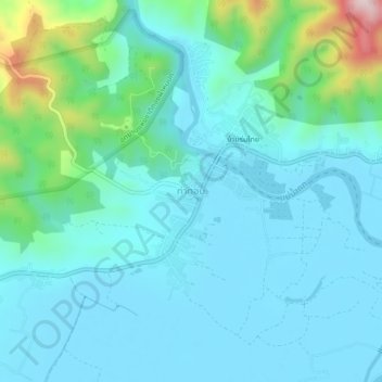
名前:Tha Tonの地形図、標高、地勢。
場所:Tha Ton, Chiang Mai Province, Thailand (20.03772 99.33909 20.07772 99.37909)
平均標高:515 m
最低標高:442 m
最大標高:878 m
寄付をします
次の冒険に備えよう:
Amazonアソシエイトとして、このサイトは対象となる購入から手数料を受け取りますが、お客様の負担はありません。
その他の地形図
地図をクリックすると、その地形、その標高、その地勢が表示されます。