
寄付をします
次の冒険に備えよう:
Amazonアソシエイトとして、このサイトは対象となる購入から手数料を受け取りますが、お客様の負担はありません。
Kingman地形図
地図をクリックすると標高が表示されます。
寄付をします
次の冒険に備えよう:
Amazonアソシエイトとして、このサイトは対象となる購入から手数料を受け取りますが、お客様の負担はありません。
Kingman
Lt. Edward Fitzgerald Beale, a U.S. Navy officer in the service of the Army Corps of Topographical Engineers, was ordered by the U.S. War Department to build a federal wagon road across the 35th parallel. His secondary orders were to test the feasibility of the use of camels as pack animals in the Southwestern desert. Beale traveled through the present-day Kingman in 1857 surveying the road and in 1859 to build the road. Beale's Wagon Road became part of U.S. Route 66 and later Interstate 40. Remnants of the wagon road can still be seen in White Cliffs Canyon in Kingman.
寄付をします
次の冒険に備えよう:
Amazonアソシエイトとして、このサイトは対象となる購入から手数料を受け取りますが、お客様の負担はありません。
この地図について
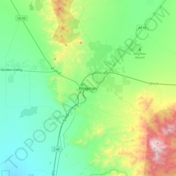
名前:Kingmanの地形図、標高、地勢。
場所:Kingman, Mohave County, Arizona, 86401, United States (35.02944 -114.21301 35.34944 -113.89301)
平均標高:1,116 m
最低標高:665 m
最大標高:2,535 m
寄付をします
次の冒険に備えよう:
Amazonアソシエイトとして、このサイトは対象となる購入から手数料を受け取りますが、お客様の負担はありません。