
寄付をします
次の冒険に備えよう:
Amazonアソシエイトとして、このサイトは対象となる購入から手数料を受け取りますが、お客様の負担はありません。
Highlands Ranch地形図
地図をクリックすると標高が表示されます。
寄付をします
次の冒険に備えよう:
Amazonアソシエイトとして、このサイトは対象となる購入から手数料を受け取りますが、お客様の負担はありません。
この地図について
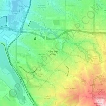
名前:Highlands Ranchの地形図、標高、地勢。
平均標高:1,725 m
最低標高:1,626 m
最大標高:1,924 m
寄付をします
次の冒険に備えよう:
Amazonアソシエイトとして、このサイトは対象となる購入から手数料を受け取りますが、お客様の負担はありません。
その他の地形図
地図をクリックすると、その地形、その標高、その地勢が表示されます。
Castle Rock
United States > Colorado > Douglas County
Castle Rock is located at 39°22′20″N 104°51′22″W / 39.37222°N 104.85611°W / 39.37222; -104.85611 (39.372212, −104.856090) at an elevation of 6,224 feet (1,897 m). Castle Rock is in central Colorado at the junction of Interstate 25 and State Highway 86, 28 mi (45 km) south of downtown…
平均標高:1,952 m
Parker
United States > Colorado > Douglas County
Parker is located in northeastern Douglas County. Its northernmost border follows the Arapahoe County line, and the city of Aurora touches the town's northeast border. The center of Parker is 23 miles (37 km) southeast of downtown Denver. Castle Rock, the Douglas County seat, is 15 miles (24 km) to the…
平均標高:1,845 m
寄付をします
次の冒険に備えよう:
Amazonアソシエイトとして、このサイトは対象となる購入から手数料を受け取りますが、お客様の負担はありません。
寄付をします
次の冒険に備えよう:
Amazonアソシエイトとして、このサイトは対象となる購入から手数料を受け取りますが、お客様の負担はありません。
Castle Pines
United States > Colorado > Douglas County
Castle Pines is located at 39°28′18″N 104°53′41″W / 39.471742°N 104.894827°W / 39.471742; -104.894827 (39.471742, -104.894827) at an elevation of 6,368 feet (1,941 m). Located on Interstate 25 in central Colorado, Castle Pines is 20 mi (32 km) south of downtown Denver and 43 mi (69 km)…
平均標高:1,924 m
寄付をします
次の冒険に備えよう:
Amazonアソシエイトとして、このサイトは対象となる購入から手数料を受け取りますが、お客様の負担はありません。
寄付をします
次の冒険に備えよう:
Amazonアソシエイトとして、このサイトは対象となる購入から手数料を受け取りますが、お客様の負担はありません。
Castle Pines
United States > Colorado > Douglas County
Castle Pines is located at 39°28′18″N 104°53′41″W / 39.471742°N 104.894827°W / 39.471742; -104.894827 (39.471742, -104.894827) at an elevation of 6,368 feet (1,941 m). Located on Interstate 25 in central Colorado, Castle Pines is 20 mi (32 km) south of downtown Denver and 43 mi (69 km)…
平均標高:1,924 m
Castle Rock
United States > Colorado > Douglas County
Castle Rock is located at 39°22′20″N 104°51′22″W / 39.37222°N 104.85611°W / 39.37222; -104.85611 (39.372212, −104.856090) at an elevation of 6,224 feet (1,897 m). Castle Rock is in central Colorado at the junction of Interstate 25 and State Highway 86, 28 mi (45 km) south of downtown…
平均標高:1,952 m
寄付をします
次の冒険に備えよう:
Amazonアソシエイトとして、このサイトは対象となる購入から手数料を受け取りますが、お客様の負担はありません。
Castle Rock
United States > Colorado > Douglas County
Castle Rock is located at 39°22′20″N 104°51′22″W / 39.37222°N 104.85611°W / 39.37222; -104.85611 (39.372212, −104.856090) at an elevation of 6,224 feet (1,897 m). Castle Rock is in central Colorado at the junction of Interstate 25 and State Highway 86, 28 mi (45 km) south of downtown…
平均標高:1,952 m