
寄付をします
次の冒険に備えよう:
Amazonアソシエイトとして、このサイトは対象となる購入から手数料を受け取りますが、お客様の負担はありません。
Peraki Bay / Pireka地形図
地図をクリックすると標高が表示されます。
寄付をします
次の冒険に備えよう:
Amazonアソシエイトとして、このサイトは対象となる購入から手数料を受け取りますが、お客様の負担はありません。
この地図について
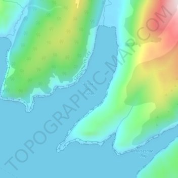
名前:Peraki Bay / Pirekaの地形図、標高、地勢。
場所:Peraki Bay / Pireka, Little River, New Zealand (-43.87068 172.81903 -43.87058 172.81913)
平均標高:89 m
最低標高:-3 m
最大標高:432 m
寄付をします
次の冒険に備えよう:
Amazonアソシエイトとして、このサイトは対象となる購入から手数料を受け取りますが、お客様の負担はありません。
その他の地形図
地図をクリックすると、その地形、その標高、その地勢が表示されます。
South Island
The South Island (Māori: Te Waipounamu, lit. 'the waters of Greenstone', officially South Island or Te Waipounamu or archaically New Munster) is the largest of the three major islands of New Zealand in surface area, the other being the smaller but more populous North Island and sparsely populated Stewart…
平均標高:201 m
寄付をします
次の冒険に備えよう:
Amazonアソシエイトとして、このサイトは対象となる購入から手数料を受け取りますが、お客様の負担はありません。
寄付をします
次の冒険に備えよう:
Amazonアソシエイトとして、このサイトは対象となる購入から手数料を受け取りますが、お客様の負担はありません。
South Island
The South Island, also officially named Te Waipounamu, is the larger of the two major islands of New Zealand in surface area, the other being the smaller but more populous North Island. It is bordered to the north by Cook Strait, to the west by the Tasman Sea, and to the south and east by the Pacific Ocean.…
平均標高:201 m
Southland
Fiordland has a wet mountain climate though conditions vary due to altitude and exposure. Rainfall is the highest in the country and varies between 6,500 and 7,500 mm annually. The farthest coastal reaches of Fiordland are characterized by a limited temperature range with increasing rainfall at higher…
平均標高:229 m
Napier
The topography puts Napier in danger from a tsunami, as the centre of the commercial city is near sea level – should the sea ever crest Marine Parade, the sea would run through to Ahuriri. Furthermore, by virtue of its pre-1931 existence, the bulk of Napier is susceptible to soil liquefaction, the risk…
平均標高:12 m
寄付をします
次の冒険に備えよう:
Amazonアソシエイトとして、このサイトは対象となる購入から手数料を受け取りますが、お客様の負担はありません。
寄付をします
次の冒険に備えよう:
Amazonアソシエイトとして、このサイトは対象となる購入から手数料を受け取りますが、お客様の負担はありません。
寄付をします
次の冒険に備えよう:
Amazonアソシエイトとして、このサイトは対象となる購入から手数料を受け取りますが、お客様の負担はありません。
Aoraki / Mount Cook National Park
New Zealand > Canterbury > Mackenzie District
Temperatures in Mount Cook Village range between extremes of −13 °C (9 °F) to 32 °C (90 °F), and typically fall just over 1 °C (34 °F) for every 200 metres (660 ft) of additional altitude.
平均標高:1,386 m
寄付をします
次の冒険に備えよう:
Amazonアソシエイトとして、このサイトは対象となる購入から手数料を受け取りますが、お客様の負担はありません。
寄付をします
次の冒険に備えよう:
Amazonアソシエイトとして、このサイトは対象となる購入から手数料を受け取りますが、お客様の負担はありません。
Fox Glacier
New Zealand > West Coast > Westland District
Chancellor Hut was built in 1930–31 on the southwest face of Chancellor Ridge, now 200 m above the glacier. Planned by mountain guides Alec and Peter Graham in 1929, all the materials had to be packed up Fox Glacier manually in 1930 in the days before helicopter airlifts. It is the oldest remaining mountain…
平均標高:1,848 m
寄付をします
次の冒険に備えよう:
Amazonアソシエイトとして、このサイトは対象となる購入から手数料を受け取りますが、お客様の負担はありません。
寄付をします
次の冒険に備えよう:
Amazonアソシエイトとして、このサイトは対象となる購入から手数料を受け取りますが、お客様の負担はありません。
寄付をします
次の冒険に備えよう:
Amazonアソシエイトとして、このサイトは対象となる購入から手数料を受け取りますが、お客様の負担はありません。
寄付をします
次の冒険に備えよう:
Amazonアソシエイトとして、このサイトは対象となる購入から手数料を受け取りますが、お客様の負担はありません。
Auckland Domain
New Zealand > Auckland > Auckland
During the 2023 Auckland Anniversary Weekend floods, a lake reformed in the lower elevation area of Pukekawa / Auckland Domain that was once a wetland.
平均標高:49 m
寄付をします
次の冒険に備えよう:
Amazonアソシエイトとして、このサイトは対象となる購入から手数料を受け取りますが、お客様の負担はありません。
Spenser Mountains
New Zealand > Tasman > Hurunui District
The Spenser Mountains is a topographic landform in the northern South Island of New Zealand. Located at the southern end of the Nelson Lakes National Park and north of the Lewis Pass they form a natural border between the Canterbury and Tasman regions. Several peaks are named after characters in Edmund…
平均標高:1,310 m
寄付をします
次の冒険に備えよう:
Amazonアソシエイトとして、このサイトは対象となる購入から手数料を受け取りますが、お客様の負担はありません。
寄付をします
次の冒険に備えよう:
Amazonアソシエイトとして、このサイトは対象となる購入から手数料を受け取りますが、お客様の負担はありません。
Chatham Island
Much of the area between the bays is taken up by the large Te Whanga Lagoon, which drains to the sea to the east, into the southern half of Hanson Bay. This lagoon covers about 160 square kilometres (62 sq mi), and drains several small rivers that rise in the hills at the south end of the island. The next…
平均標高:18 m
寄付をします
次の冒険に備えよう:
Amazonアソシエイトとして、このサイトは対象となる購入から手数料を受け取りますが、お客様の負担はありません。
寄付をします
次の冒険に備えよう:
Amazonアソシエイトとして、このサイトは対象となる購入から手数料を受け取りますが、お客様の負担はありません。
寄付をします
次の冒険に備えよう:
Amazonアソシエイトとして、このサイトは対象となる購入から手数料を受け取りますが、お客様の負担はありません。
Methven
New Zealand > Canterbury > Ashburton District
Methven is a small town in the Canterbury region of the South Island of New Zealand. It is located near the western edge of the Canterbury Plains, 34 km (21 mi) north of Ashburton and 95 km (59 mi) west of Christchurch, and at an elevation of 320 m (1,050 ft). The town is a service centre for agriculture in…
平均標高:321 m
寄付をします
次の冒険に備えよう:
Amazonアソシエイトとして、このサイトは対象となる購入から手数料を受け取りますが、お客様の負担はありません。
寄付をします
次の冒険に備えよう:
Amazonアソシエイトとして、このサイトは対象となる購入から手数料を受け取りますが、お客様の負担はありません。
寄付をします
次の冒険に備えよう:
Amazonアソシエイトとして、このサイトは対象となる購入から手数料を受け取りますが、お客様の負担はありません。
寄付をします
次の冒険に備えよう:
Amazonアソシエイトとして、このサイトは対象となる購入から手数料を受け取りますが、お客様の負担はありません。
Napier
The topography puts Napier in danger from a tsunami, as the centre of the commercial city is near sea level – should the sea ever crest Marine Parade, the sea would run through to Ahuriri. Furthermore, by virtue of its pre-1931 existence, the bulk of Napier is susceptible to soil liquefaction, the risk…
平均標高:12 m
寄付をします
次の冒険に備えよう:
Amazonアソシエイトとして、このサイトは対象となる購入から手数料を受け取りますが、お客様の負担はありません。
Auckland
The Auckland Volcanic Field has contributed greatly to the growth and prosperity of the Auckland Region since the area was settled by humans. Initially, the maunga (scoria cones) were occupied and established as pā (fortified settlements) by Māori due to the strategic advantage their elevation provided in…
平均標高:44 m
寄付をします
次の冒険に備えよう:
Amazonアソシエイトとして、このサイトは対象となる購入から手数料を受け取りますが、お客様の負担はありません。
寄付をします
次の冒険に備えよう:
Amazonアソシエイトとして、このサイトは対象となる購入から手数料を受け取りますが、お客様の負担はありません。
寄付をします
次の冒険に備えよう:
Amazonアソシエイトとして、このサイトは対象となる購入から手数料を受け取りますが、お客様の負担はありません。