
寄付をします
次の冒険に備えよう:
Amazonアソシエイトとして、このサイトは対象となる購入から手数料を受け取りますが、お客様の負担はありません。
St Ishmaels地形図
地図をクリックすると標高が表示されます。
寄付をします
次の冒険に備えよう:
Amazonアソシエイトとして、このサイトは対象となる購入から手数料を受け取りますが、お客様の負担はありません。
この地図について
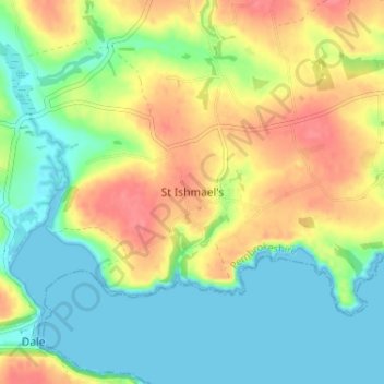
名前:St Ishmaelsの地形図、標高、地勢。
場所:St Ishmaels, Pembrokeshire, Wales, SA62 3SX, United Kingdom (51.70317 -5.16264 51.74317 -5.12264)
平均標高:27 m
最低標高:-1 m
最大標高:64 m
寄付をします
次の冒険に備えよう:
Amazonアソシエイトとして、このサイトは対象となる購入から手数料を受け取りますが、お客様の負担はありません。
その他の地形図
地図をクリックすると、その地形、その標高、その地勢が表示されます。
寄付をします
次の冒険に備えよう:
Amazonアソシエイトとして、このサイトは対象となる購入から手数料を受け取りますが、お客様の負担はありません。
Milford Haven
United Kingdom > Wales > Pembrokeshire
One of the earliest notable figures from the Milford Haven area is Howell Davis, a pirate born in 1680. He was shot dead in 1719 on the Portuguese island of Príncipe. Other famous residents connected as seafarers include Isaac Davis, a former seaman who was engaged in the fur trade between the Pacific…
平均標高:36 m
寄付をします
次の冒険に備えよう:
Amazonアソシエイトとして、このサイトは対象となる購入から手数料を受け取りますが、お客様の負担はありません。
Preseli Mountains
United Kingdom > Wales > Pembrokeshire > Puncheston
Samuel Lewis's A Topographical Dictionary of Wales published in 1833 said of Maenclochog parish.
平均標高:217 m
寄付をします
次の冒険に備えよう:
Amazonアソシエイトとして、このサイトは対象となる購入から手数料を受け取りますが、お客様の負担はありません。
寄付をします
次の冒険に備えよう:
Amazonアソシエイトとして、このサイトは対象となる購入から手数料を受け取りますが、お客様の負担はありません。
寄付をします
次の冒険に備えよう:
Amazonアソシエイトとして、このサイトは対象となる購入から手数料を受け取りますが、お客様の負担はありません。
Milford Haven
United Kingdom > Wales > Pembrokeshire
One of the earliest notable figures from the Milford Haven area is Howell Davis, a pirate born in 1680. He was shot dead in 1719 on the Portuguese island of Príncipe. Other famous residents connected as seafarers include Isaac Davis, a former seaman who was engaged in the fur trade between the Pacific…
平均標高:36 m
寄付をします
次の冒険に備えよう:
Amazonアソシエイトとして、このサイトは対象となる購入から手数料を受け取りますが、お客様の負担はありません。
寄付をします
次の冒険に備えよう:
Amazonアソシエイトとして、このサイトは対象となる購入から手数料を受け取りますが、お客様の負担はありません。
Puncheston
United Kingdom > Wales > Pembrokeshire
A map of 1578 shows the parish as Castle Male, presumably a phonetic spelling of the Welsh name by the English mapmaker. Lewis's Topographical Dictionary of 1844 gives 326 inhabitants (the 1849 edition gives 255) for the parish, which includes the village and a number of outlying residences and farms. Lewis…
平均標高:165 m
寄付をします
次の冒険に備えよう:
Amazonアソシエイトとして、このサイトは対象となる購入から手数料を受け取りますが、お客様の負担はありません。