
寄付をします
次の冒険に備えよう:
Amazonアソシエイトとして、このサイトは対象となる購入から手数料を受け取りますが、お客様の負担はありません。
Zamora地形図
地図をクリックすると標高が表示されます。
寄付をします
次の冒険に備えよう:
Amazonアソシエイトとして、このサイトは対象となる購入から手数料を受け取りますが、お客様の負担はありません。
Zamora
The city of Zamora is an important economic center in the state and the most significant population center between the cities of Morelia and Guadalajara. The city is located on the Tarascan Plateau in the northwestern part of the state, at an elevation of 1,567 m (5,141 ft) above sea level. Zamora is surrounded by the fertile Tziróndaro Valley which is an important agricultural area that exports large amounts of produce to the United States.
寄付をします
次の冒険に備えよう:
Amazonアソシエイトとして、このサイトは対象となる購入から手数料を受け取りますが、お客様の負担はありません。
この地図について
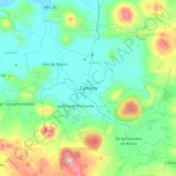
名前:Zamoraの地形図、標高、地勢。
場所:Zamora, Michoacán, 59670, Mexico (19.82289 -102.44363 20.14289 -102.12363)
平均標高:1,798 m
最低標高:1,526 m
最大標高:2,767 m
寄付をします
次の冒険に備えよう:
Amazonアソシエイトとして、このサイトは対象となる購入から手数料を受け取りますが、お客様の負担はありません。