
寄付をします
次の冒険に備えよう:
Amazonアソシエイトとして、このサイトは対象となる購入から手数料を受け取りますが、お客様の負担はありません。
Kabangbang地形図
地図をクリックすると標高が表示されます。
寄付をします
次の冒険に備えよう:
Amazonアソシエイトとして、このサイトは対象となる購入から手数料を受け取りますが、お客様の負担はありません。
この地図について
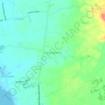
名前:Kabangbangの地形図、標高、地勢。
場所:Kabangbang, Cebu, Central Visayas, 6062, Philippines (11.19093 123.70301 11.23093 123.74301)
平均標高:20 m
最低標高:0 m
最大標高:72 m
寄付をします
次の冒険に備えよう:
Amazonアソシエイトとして、このサイトは対象となる購入から手数料を受け取りますが、お客様の負担はありません。
その他の地形図
地図をクリックすると、その地形、その標高、その地勢が表示されます。
Oslob
Generally, topography of the area is hilly and rolling, dominated by open grasslands and second growth forest. There are fairly level and rolling plateaus and valleys spread throughout the interior. These are some of the most suitable areas for upland agriculture. The highest mountain peak is 800 metres (2,600…
平均標高:99 m
寄付をします
次の冒険に備えよう:
Amazonアソシエイトとして、このサイトは対象となる購入から手数料を受け取りますが、お客様の負担はありません。
寄付をします
次の冒険に備えよう:
Amazonアソシエイトとして、このサイトは対象となる購入から手数料を受け取りますが、お客様の負担はありません。