
寄付をします
次の冒険に備えよう:
Amazonアソシエイトとして、このサイトは対象となる購入から手数料を受け取りますが、お客様の負担はありません。
Laurel Hill地形図
地図をクリックすると標高が表示されます。
寄付をします
次の冒険に備えよう:
Amazonアソシエイトとして、このサイトは対象となる購入から手数料を受け取りますが、お客様の負担はありません。
この地図について
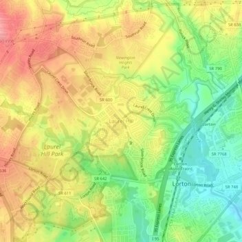
名前:Laurel Hillの地形図、標高、地勢。
場所:Laurel Hill, Fairfax County, Virginia, 22079, United States (38.69470 -77.25319 38.73470 -77.21319)
平均標高:57 m
最低標高:4 m
最大標高:106 m
寄付をします
次の冒険に備えよう:
Amazonアソシエイトとして、このサイトは対象となる購入から手数料を受け取りますが、お客様の負担はありません。
その他の地形図
地図をクリックすると、その地形、その標高、その地勢が表示されます。
McLean
United States > Virginia > Fairfax County > McLean
McLean is located at 38°56′03″N 77°10′39″W / 38.93417°N 77.17750°W / 38.93417; -77.17750 (38.9342776, −77.1774801) at an elevation of 285 feet (87 m). Located on the Capital Beltway (Interstate 495) in Northern Virginia, central McLean is 8 miles (13 km) northwest of downtown Washington,…
平均標高:89 m
寄付をします
次の冒険に備えよう:
Amazonアソシエイトとして、このサイトは対象となる購入から手数料を受け取りますが、お客様の負担はありません。
Tysons
United States > Virginia > Fairfax County > Tysons
Tysons is located at 38°55′7″N 77°13′47″W / 38.91861°N 77.22972°W / 38.91861; -77.22972 (38.918485, −77.229833) at an elevation of 486 feet (148 m). Located in Northern Virginia at the intersection of Virginia State Route 123 and State Route 7, Tysons is 11 miles (18 km) west of downtown…
平均標高:123 m
寄付をします
次の冒険に備えよう:
Amazonアソシエイトとして、このサイトは対象となる購入から手数料を受け取りますが、お客様の負担はありません。
Lorton
United States > Virginia > Fairfax County > Lorton
According to the United States Census Bureau, the Lorton CDP has a total area of 5.4 square miles (13.9 km2), of which 5.3 square miles (13.7 km2) is land and 0.1 square miles (0.2 km2), or 1.39%, is water. The elevation ranges from sea level at the Prince William County line (the Occoquan River) to slightly…
平均標高:37 m
寄付をします
次の冒険に備えよう:
Amazonアソシエイトとして、このサイトは対象となる購入から手数料を受け取りますが、お客様の負担はありません。
寄付をします
次の冒険に備えよう:
Amazonアソシエイトとして、このサイトは対象となる購入から手数料を受け取りますが、お客様の負担はありません。
寄付をします
次の冒険に備えよう:
Amazonアソシエイトとして、このサイトは対象となる購入から手数料を受け取りますが、お客様の負担はありません。
寄付をします
次の冒険に備えよう:
Amazonアソシエイトとして、このサイトは対象となる購入から手数料を受け取りますが、お客様の負担はありません。
McLean
United States > Virginia > Fairfax County > McLean
McLean is located at 38°56′03″N 77°10′39″W / 38.93417°N 77.17750°W / 38.93417; -77.17750 (38.9342776, -77.1774801) at an elevation of 285 feet (87 m). Located on the Capital Beltway (Interstate 495) in Northern Virginia, central McLean is 8 miles (13 km) northwest of downtown Washington,…
平均標高:89 m
寄付をします
次の冒険に備えよう:
Amazonアソシエイトとして、このサイトは対象となる購入から手数料を受け取りますが、お客様の負担はありません。
Vienna
United States > Virginia > Fairfax County
Vienna is located at 38°54′N 77°16′W / 38.900°N 77.267°W / 38.900; -77.267 (38.8991, −77.2607), at an elevation of 358 feet (109 meters). It lies in the Piedmont approximately 5.5 miles (8.9 km) southwest of the Potomac River. Wolftrap Creek, a tributary of nearby Difficult Run, flows north…
平均標高:117 m
George Washington's Mount Vernon
United States > Virginia > Fairfax County > Mount Vernon
Visitors to Mount Vernon now see Washington's study, a room to which in the 18th century only a privileged few were granted entry. This simply furnished room has a combined bathroom, dressing room and office; the room was so private that few contemporary descriptions exist. Its walls are lined with naturally…
平均標高:14 m
寄付をします
次の冒険に備えよう:
Amazonアソシエイトとして、このサイトは対象となる購入から手数料を受け取りますが、お客様の負担はありません。
寄付をします
次の冒険に備えよう:
Amazonアソシエイトとして、このサイトは対象となる購入から手数料を受け取りますが、お客様の負担はありません。
Lorton
United States > Virginia > Fairfax County
According to the United States Census Bureau, the Lorton CDP has a total area of 5.4 square miles (13.9 km2), of which 5.3 square miles (13.7 km2) is land and 0.1 square miles (0.2 km2), or 1.39%, is water. The elevation ranges from sea level at the Prince William County line (the Occoquan River) to slightly…
平均標高:41 m
寄付をします
次の冒険に備えよう:
Amazonアソシエイトとして、このサイトは対象となる購入から手数料を受け取りますが、お客様の負担はありません。
寄付をします
次の冒険に備えよう:
Amazonアソシエイトとして、このサイトは対象となる購入から手数料を受け取りますが、お客様の負担はありません。
寄付をします
次の冒険に備えよう:
Amazonアソシエイトとして、このサイトは対象となる購入から手数料を受け取りますが、お客様の負担はありません。
寄付をします
次の冒険に備えよう:
Amazonアソシエイトとして、このサイトは対象となる購入から手数料を受け取りますが、お客様の負担はありません。
寄付をします
次の冒険に備えよう:
Amazonアソシエイトとして、このサイトは対象となる購入から手数料を受け取りますが、お客様の負担はありません。
寄付をします
次の冒険に備えよう:
Amazonアソシエイトとして、このサイトは対象となる購入から手数料を受け取りますが、お客様の負担はありません。
寄付をします
次の冒険に備えよう:
Amazonアソシエイトとして、このサイトは対象となる購入から手数料を受け取りますが、お客様の負担はありません。
寄付をします
次の冒険に備えよう:
Amazonアソシエイトとして、このサイトは対象となる購入から手数料を受け取りますが、お客様の負担はありません。
Tysons
United States > Virginia > Fairfax County
Tysons is located at 38°55′7″N 77°13′47″W / 38.91861°N 77.22972°W / 38.91861; -77.22972 (38.918485, −77.229833) at an elevation of 486 feet (148 m). Located in Northern Virginia at the intersection of Virginia State Route 123 and State Route 7, Tysons is 11 miles (18 km) west of downtown…
平均標高:122 m