
このサイトをサポートしていただきありがとうございます ❤️
寄付をします
寄付をします
次の冒険に備えよう:
Amazonアソシエイトとして、このサイトは対象となる購入から手数料を受け取りますが、お客様の負担はありません。
Kandahar地形図
地図をクリックすると標高が表示されます。
このサイトをサポートしていただきありがとうございます ❤️
寄付をします
寄付をします
次の冒険に備えよう:
Amazonアソシエイトとして、このサイトは対象となる購入から手数料を受け取りますが、お客様の負担はありません。
Kandahar
Kandahar is a city in Afghanistan, located in the south of the country on Arghandab River, at an elevation of 1,010 m (3,310 ft). It is Afghanistan's second largest city, after Kabul, with a population of about 614,118 in 2015. It is the capital of Kandahar Province and the centre of the larger cultural region called Loy Kandahar.
このサイトをサポートしていただきありがとうございます ❤️
寄付をします
寄付をします
次の冒険に備えよう:
Amazonアソシエイトとして、このサイトは対象となる購入から手数料を受け取りますが、お客様の負担はありません。
この地図について
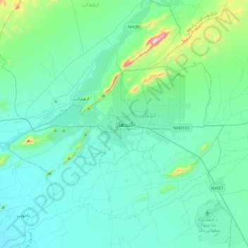
名前:Kandaharの地形図、標高、地勢。
場所:Kandahar, Kandahar Province, 3801, Afghanistan (31.46057 65.55576 31.78057 65.87576)
平均標高:1,048 m
最低標高:940 m
最大標高:1,776 m
このサイトをサポートしていただきありがとうございます ❤️
寄付をします
寄付をします
次の冒険に備えよう:
Amazonアソシエイトとして、このサイトは対象となる購入から手数料を受け取りますが、お客様の負担はありません。