
寄付をします
次の冒険に備えよう:
Amazonアソシエイトとして、このサイトは対象となる購入から手数料を受け取りますが、お客様の負担はありません。
Glentanner地形図
地図をクリックすると標高が表示されます。
寄付をします
次の冒険に備えよう:
Amazonアソシエイトとして、このサイトは対象となる購入から手数料を受け取りますが、お客様の負担はありません。
この地図について
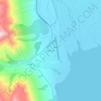
名前:Glentannerの地形図、標高、地勢。
場所:Glentanner, Mackenzie District, Canterbury, New Zealand (-43.93157 170.10509 -43.89157 170.14509)
平均標高:647 m
最低標高:530 m
最大標高:1,200 m
寄付をします
次の冒険に備えよう:
Amazonアソシエイトとして、このサイトは対象となる購入から手数料を受け取りますが、お客様の負担はありません。
その他の地形図
地図をクリックすると、その地形、その標高、その地勢が表示されます。
Aoraki / Mount Cook National Park
New Zealand > Canterbury > Mackenzie District
Temperatures in Mount Cook Village range between extremes of −13 °C (9 °F) to 32 °C (90 °F), and typically fall just over 1 °C (34 °F) for every 200 metres (660 ft) of additional altitude.
平均標高:1,386 m
Tasman Glacier
New Zealand > Canterbury > Mackenzie District
At 23.5 kilometres (14.6 mi) in length, Tasman Glacier is still New Zealand's longest glacier, despite shrinking considerably from the 1990s onwards. It is as much as 4 kilometres (2.5 mi) wide and 600 metres (2,000 ft) thick, and lies entirely within the borders of Aoraki / Mount Cook National Park. The…
平均標高:1,884 m
Lake Tekapo
New Zealand > Canterbury > Mackenzie District
Lake Tekapo (Māori: Takapō) is the second-largest of three roughly parallel lakes running north–south along the northern edge of the Mackenzie Basin in the South Island of New Zealand (the others are Lake Pukaki and Lake Ōhau). It covers an area of 83 square kilometres (32 sq mi) and is at an altitude of…
平均標高:1,025 m
寄付をします
次の冒険に備えよう:
Amazonアソシエイトとして、このサイトは対象となる購入から手数料を受け取りますが、お客様の負担はありません。