
寄付をします
次の冒険に備えよう:
Amazonアソシエイトとして、このサイトは対象となる購入から手数料を受け取りますが、お客様の負担はありません。
Derry/Londonderry地形図
地図をクリックすると標高が表示されます。
寄付をします
次の冒険に備えよう:
Amazonアソシエイトとして、このサイトは対象となる購入から手数料を受け取りますが、お客様の負担はありません。
Derry/Londonderry
Derry is characterised by its distinctively hilly topography. The River Foyle forms a deep valley as it flows through the city, making Derry a place of very steep streets and sudden, startling views. The original walled city of Londonderry lies on a hill on the west bank of the River Foyle. In the past, the river branched and enclosed this wooded hill as an island; over the centuries, however, the western branch of the river dried up and became a low-lying and boggy district that is now called the Bogside.
寄付をします
次の冒険に備えよう:
Amazonアソシエイトとして、このサイトは対象となる購入から手数料を受け取りますが、お客様の負担はありません。
この地図について
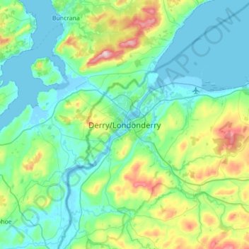
名前:Derry/Londonderryの地形図、標高、地勢。
平均標高:88 m
最低標高:-5 m
最大標高:478 m
寄付をします
次の冒険に備えよう:
Amazonアソシエイトとして、このサイトは対象となる購入から手数料を受け取りますが、お客様の負担はありません。