
寄付をします
次の冒険に備えよう:
Amazonアソシエイトとして、このサイトは対象となる購入から手数料を受け取りますが、お客様の負担はありません。
New River地形図
地図をクリックすると標高が表示されます。
寄付をします
次の冒険に備えよう:
Amazonアソシエイトとして、このサイトは対象となる購入から手数料を受け取りますが、お客様の負担はありません。
この地図について
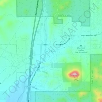
名前:New Riverの地形図、標高、地勢。
場所:New River, Maricopa County, Arizona, 85080, United States (33.89587 -112.15599 33.93587 -112.11599)
平均標高:647 m
最低標高:588 m
最大標高:895 m
寄付をします
次の冒険に備えよう:
Amazonアソシエイトとして、このサイトは対象となる購入から手数料を受け取りますが、お客様の負担はありません。
その他の地形図
地図をクリックすると、その地形、その標高、その地勢が表示されます。
Fountain Hills
United States > Arizona > Maricopa County
Fountain Hills is in eastern Maricopa County, on the eastern edge of the Phoenix urbanized area. It is 31 miles (50 km) northeast of downtown Phoenix and sits on the east side of the south end of the McDowell Mountains. According to the U.S. Census Bureau, the town has a total area of 20.4 square miles (53…
平均標高:503 m
寄付をします
次の冒険に備えよう:
Amazonアソシエイトとして、このサイトは対象となる購入から手数料を受け取りますが、お客様の負担はありません。
Gila Bend
United States > Arizona > Maricopa County
According to the United States Census Bureau, the town has a total area of 64.4 square miles (167 km2), all of it land.[2] Situated at 735 feet (224 m) above sea level, Gila Bend has the lowest elevation of any city in Maricopa County and in Greater Phoenix overall.[19]
平均標高:257 m