
寄付をします
次の冒険に備えよう:
Amazonアソシエイトとして、このサイトは対象となる購入から手数料を受け取りますが、お客様の負担はありません。
Chester地形図
地図をクリックすると標高が表示されます。
寄付をします
次の冒険に備えよう:
Amazonアソシエイトとして、このサイトは対象となる購入から手数料を受け取りますが、お客様の負担はありません。
この地図について
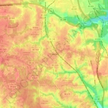
名前:Chesterの地形図、標高、地勢。
場所:Chester, Chesterfield County, Virginia, 23831, United States (37.31622 -77.48606 37.39622 -77.40606)
平均標高:46 m
最低標高:2 m
最大標高:69 m
寄付をします
次の冒険に備えよう:
Amazonアソシエイトとして、このサイトは対象となる購入から手数料を受け取りますが、お客様の負担はありません。
その他の地形図
地図をクリックすると、その地形、その標高、その地勢が表示されます。
Bon Air
United States > Virginia > Chesterfield County > Bon Air
In the 19th century, it was believed that the higher elevation and distance from the urban area of Richmond provided a more healthful atmosphere, particularly in the hot summer months in central Virginia. With its nearby location and greater elevation, Bon Air offered these features nearby, and was founded as…
平均標高:88 m
寄付をします
次の冒険に備えよう:
Amazonアソシエイトとして、このサイトは対象となる購入から手数料を受け取りますが、お客様の負担はありません。
寄付をします
次の冒険に備えよう:
Amazonアソシエイトとして、このサイトは対象となる購入から手数料を受け取りますが、お客様の負担はありません。
Bon Air
United States > Virginia > Chesterfield County > Bon Air
In the 19th century, it was believed that the higher elevation and distance from the urban area of Richmond provided a more healthful atmosphere, particularly in the hot summer months in central Virginia. With its nearby location and greater elevation, Bon Air offered these features nearby, and was founded as…
平均標高:87 m