
寄付をします
次の冒険に備えよう:
Amazonアソシエイトとして、このサイトは対象となる購入から手数料を受け取りますが、お客様の負担はありません。
Sombrerete地形図
地図をクリックすると標高が表示されます。
寄付をします
次の冒険に備えよう:
Amazonアソシエイトとして、このサイトは対象となる購入から手数料を受け取りますが、お客様の負担はありません。
Sombrerete
The region is between the Sierra Madre Occidental and the central highlands of Mexico. The municipality is in a valley is surrounded on all sides by small mountain ranges such as the Sierra de Sombrerete and the Sierra de Santa María with prominent elevations such as the Cerro Grande, Cerro Reyes, Cerro Sombreretillo and Cerro Alto. The town has an altitude of about 2,300 meters above sea level with the highest elevations over 2,500.
寄付をします
次の冒険に備えよう:
Amazonアソシエイトとして、このサイトは対象となる購入から手数料を受け取りますが、お客様の負担はありません。
この地図について
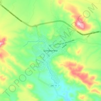
名前:Sombrereteの地形図、標高、地勢。
場所:Sombrerete, Zacatecas, 99100, Mexico (23.59543 -103.68101 23.67543 -103.60101)
平均標高:2,401 m
最低標高:2,234 m
最大標高:2,701 m
寄付をします
次の冒険に備えよう:
Amazonアソシエイトとして、このサイトは対象となる購入から手数料を受け取りますが、お客様の負担はありません。