
寄付をします
次の冒険に備えよう:
Amazonアソシエイトとして、このサイトは対象となる購入から手数料を受け取りますが、お客様の負担はありません。
Laramie地形図
地図をクリックすると標高が表示されます。
寄付をします
次の冒険に備えよう:
Amazonアソシエイトとして、このサイトは対象となる購入から手数料を受け取りますが、お客様の負担はありません。
Laramie
Laramie is on a high plain between two mountain ranges, the Snowy Range, about 30 miles (48 km) to the west, and the Laramie Range, 7 miles (11 km) to the east. The city's elevation above sea level is approximately 7,165 feet (2,184 m). The Laramie River runs through Laramie toward its confluence with the North Platte River east of the Laramie Range.
寄付をします
次の冒険に備えよう:
Amazonアソシエイトとして、このサイトは対象となる購入から手数料を受け取りますが、お客様の負担はありません。
この地図について
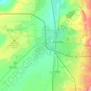
名前:Laramieの地形図、標高、地勢。
場所:Laramie, Albany County, Wyoming, United States (41.27742 -105.69729 41.33581 -105.52819)
平均標高:2,219 m
最低標高:2,166 m
最大標高:2,462 m
寄付をします
次の冒険に備えよう:
Amazonアソシエイトとして、このサイトは対象となる購入から手数料を受け取りますが、お客様の負担はありません。
その他の地形図
地図をクリックすると、その地形、その標高、その地勢が表示されます。
Medicine Bow Peak
United States > Wyoming > Albany County
Medicine Bow Peak (12,018 ft (3,663 m)) is the highest peak in the Snowy Range, a part of the Medicine Bow Mountains, about 35 miles (56 km) west of Laramie, Wyoming. It lies within Medicine Bow National Forest and is the highest point in southern Wyoming. The summit lies in extreme western Albany County, but…
平均標高:3,396 m
Laramie
United States > Wyoming > Albany County
Laramie (/ˈlærəmi/) is a city in and the county seat of Albany County, Wyoming, United States, known for its high elevation at 7,200 feet (2,200 m), for its railroad history, and as the home of the University of Wyoming. The population was 31,407 at the 2020 census, making it the fourth-most populous city…
平均標高:2,218 m
Laramie
United States > Wyoming > Albany County
Laramie (/ˈlærəmi/) is a city in and the county seat of Albany County, Wyoming, United States, known for its high elevation at 7,200 feet (2,200 m), railroad history, and is the home of the University of Wyoming. The population was 31,407 at the 2020 census, making it the fourth-most populous city in…
平均標高:2,218 m
寄付をします
次の冒険に備えよう:
Amazonアソシエイトとして、このサイトは対象となる購入から手数料を受け取りますが、お客様の負担はありません。
Laramie
United States > Wyoming > Albany County > Laramie
Laramie is on a high plain between two mountain ranges, the Snowy Range, about 30 miles (48 km) to the west, and the Laramie Range, 7 miles (11 km) to the east. The city's elevation above sea level is approximately 7,165 feet (2,184 m). The Laramie River runs through Laramie toward its confluence with the…
平均標高:2,299 m