
寄付をします
次の冒険に備えよう:
Amazonアソシエイトとして、このサイトは対象となる購入から手数料を受け取りますが、お客様の負担はありません。
Bandung地形図
地図をクリックすると標高が表示されます。
寄付をします
次の冒険に備えよう:
Amazonアソシエイトとして、このサイトは対象となる購入から手数料を受け取りますが、お客様の負担はありません。
Bandung
Bandung, the capital of West Java province, located about 180 kilometres (110 mi) southeast of Jakarta, is the third-largest city in Indonesia. Its elevation is 768 metres (2,520 ft) above sea level and is surrounded by up to 2,400 metres (7,900 feet) high Late Tertiary and Quaternary volcanic terrain. The 400 km2 flat of central Bandung plain is situated in the middle of 2,340.88 square kilometres (903.82 sq mi) wide of the Bandung Basin; the basin comprises Bandung, the Cimahi city, part of Bandung Regency, part of West Bandung Regency, and part of Sumedang Regency. The basin's main river is the Citarum; one of its branches, the Cikapundung, divides Bandung from north to south before it merges with Citarum again in Dayeuhkolot. The Bandung Basin is an essential source of water for potable water, irrigation, and fisheries, with its 6,147 million m3 (217.1 billion cu ft) of groundwater being a significant reservoir for the city. The northern section of Bandung is hillier than other parts of the city, and the unique truncated flat-peak shape of the Tangkuban Perahu volcano (Tangkuban Perahu literally means 'upside-down boat') can be seen from the city to the north. Long-term volcanic activity has created fertile andisol soil in the north, suitable for intensive rice, fruit, tea, tobacco, and coffee plantations. In the south and east, alluvial soils deposited by the Cikapundung river predominate.
寄付をします
次の冒険に備えよう:
Amazonアソシエイトとして、このサイトは対象となる購入から手数料を受け取りますが、お客様の負担はありません。
この地図について
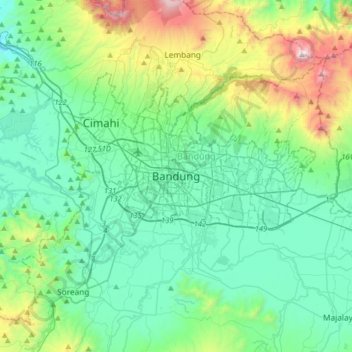
名前:Bandungの地形図、標高、地勢。
場所:Bandung, West Java, 40252, Indonesia (-7.09447 107.44495 -6.77447 107.76495)
平均標高:879 m
最低標高:521 m
最大標高:2,173 m
寄付をします
次の冒険に備えよう:
Amazonアソシエイトとして、このサイトは対象となる購入から手数料を受け取りますが、お客様の負担はありません。
その他の地形図
地図をクリックすると、その地形、その標高、その地勢が表示されます。