
寄付をします
次の冒険に備えよう:
Amazonアソシエイトとして、このサイトは対象となる購入から手数料を受け取りますが、お客様の負担はありません。
Seez Moulins地形図
地図をクリックすると標高が表示されます。
寄付をします
次の冒険に備えよう:
Amazonアソシエイトとして、このサイトは対象となる購入から手数料を受け取りますが、お客様の負担はありません。
この地図について
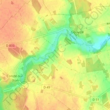
名前:Seez Moulinsの地形図、標高、地勢。
平均標高:167 m
最低標高:141 m
最大標高:183 m
寄付をします
次の冒険に備えよう:
Amazonアソシエイトとして、このサイトは対象となる購入から手数料を受け取りますが、お客様の負担はありません。
その他の地形図
地図をクリックすると、その地形、その標高、その地勢が表示されます。
Mesnils-sur-Iton
France > Normandie > Eure > Mesnils-sur-Iton
Plusieurs études ont été menées afin de caractériser les types climatiques auxquels est exposé le territoire national. Les zonages obtenus diffèrent selon les méthodes utilisées, la nature et le nombre des paramètres pris en compte, le maillage territorial des données et la période de référence.…
平均標高:159 m
Buis-sur-Damville
France > Normandie > Eure > Mesnils-sur-Iton
L'altitude à la mairie est de 159 mètres.
平均標高:156 m
寄付をします
次の冒険に備えよう:
Amazonアソシエイトとして、このサイトは対象となる購入から手数料を受け取りますが、お客様の負担はありません。