
このサイトをサポートしていただきありがとうございます ❤️
寄付をします
寄付をします
次の冒険に備えよう:
Amazonアソシエイトとして、このサイトは対象となる購入から手数料を受け取りますが、お客様の負担はありません。
Crowborough地形図
地図をクリックすると標高が表示されます。
このサイトをサポートしていただきありがとうございます ❤️
寄付をします
寄付をします
次の冒険に備えよう:
Amazonアソシエイトとして、このサイトは対象となる購入から手数料を受け取りますが、お客様の負担はありません。
Crowborough
In the late 19th century Crowborough was promoted as a health resort based on its high elevation, the rolling hills and surrounding forest. Estate Agents even called it "Scotland in Sussex". The town's golf course opened in 1895, followed by a fire station and hospital in 1900.
このサイトをサポートしていただきありがとうございます ❤️
寄付をします
寄付をします
次の冒険に備えよう:
Amazonアソシエイトとして、このサイトは対象となる購入から手数料を受け取りますが、お客様の負担はありません。
この地図について
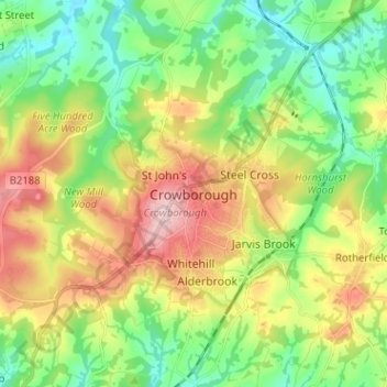
名前:Crowboroughの地形図、標高、地勢。
平均標高:125 m
最低標高:48 m
最大標高:244 m
このサイトをサポートしていただきありがとうございます ❤️
寄付をします
寄付をします
次の冒険に備えよう:
Amazonアソシエイトとして、このサイトは対象となる購入から手数料を受け取りますが、お客様の負担はありません。